
Geographic Region: USA-TEXAS
Feature: OIL FIELDS, AGR., HOBBS
|
Geographic Region: USA-TEXAS Feature: OIL FIELDS, AGR., HOBBS |
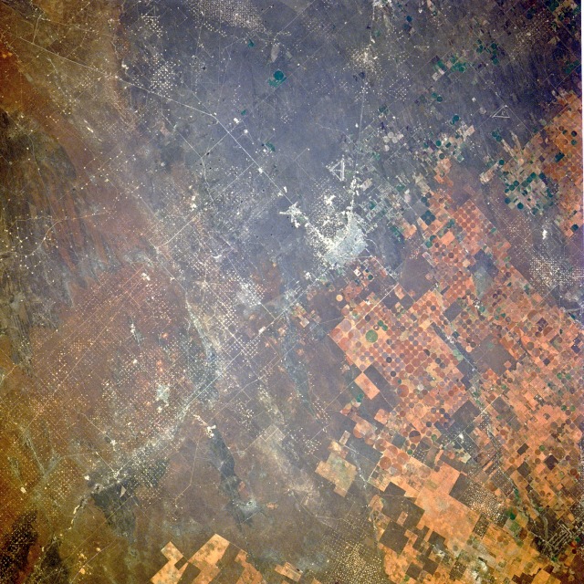 |
| STS61A-41-0079 Hobbs, New Mexico, U.S.A, November 1985 Hobbs, visible near the center of this near-vertical photograph, is situated near the southwest border of the U.S. Great Plains region. Described as one of the last great oil-boom towns in the United States, Hobbs is located in southeast New Mexico, less than 3 miles (5 kilometers) from the Texas border. During the late l920s when oil and natural gas were discovered, the city became a dynamic urban area and now has a population of approximately 30 000. Two major industries--oil and gas production and farming--are evidenced in the photograph. The largest acreage is occupied by the oil industry with the darker area showing thousands of wellheads and producing oil and natural gas fields. Each tiny white dot is a gas or oil well drilled during the last 80 years. In contrast, the cultivated field patterns east of Hobbs are various shades of brown, with the majority of fields having a circular pattern within a square box. Since the climate in this region is semiarid, cotton and grain fields must be irrigated. Irrigation is accomplished by center-pivot irrigation, a process in which a large mechanical arm rotates around a center pivot, dispensing water along the long arm mechanism. |
| Images: | All Available Images Low-Resolution 188k |
|
| Mission: | STS61A |
|
| Roll - Frame: | 41 - 79 |
|
| Geographical Name: | USA-TEXAS |
|
| Features: | OIL FIELDS, AGR., HOBBS |
|
| Center Lat x Lon: | 32.5N x 103W |
|
| Film Exposure: | N | N=Normal exposure, U=Under exposed, O=Over exposed, F=out of Focus |
| Percentage of Cloud Cover-CLDP: | 0 |
|
| Camera:: | HB |
|
| Camera Tilt: | 14 | LO=Low Oblique, HO=High Oblique, NV=Near Vertical |
| Camera Focal Length: | 250 |
|
| Nadir to Photo Center Direction: | N | The direction from the nadir to the center point, N=North, S=South, E=East, W=West |
| Stereo?: | Y | Y=Yes there is an adjacent picture of the same area, N=No there isn't |
| Orbit Number: | 80 |
|
| Date: | 19851104 | YYYYMMDD |
| Time: | 165758 | GMT HHMMSS |
| Nadir Lat: | 31.8N |
Latitude of suborbital point of spacecraft |
| Nadir Lon: | 103.3W |
Longitude of suborbital point of spacecraft |
| Sun Azimuth: | 149 | Clockwise angle in degrees from north to the sun measured at the nadir point |
| Space Craft Altitude: | 177 | nautical miles |
| Sun Elevation: | 37 | Angle in degrees between the horizon and the sun, measured at the nadir point |
| Land Views: | PLAIN |
|
| Water Views: | |
|
| Atmosphere Views: | |
|
| Man Made Views: | URBAN AREA, AGRICULTURE |
|
| City Views: | |
|
Photo is not associated with any sequences | ||
| NASA Home Page |
JSC Home Page |
JSC Digital Image Collection |
Earth Science & Remote Sensing |
|
This service is provided by the International Space Station program and the JSC Earth Science & Remote Sensing Unit, ARES Division, Exploration Integration Science Directorate.

|