
Geographic Region: AUSTRALIA-NSW
Feature: SYDNEY, COASTLINE, SUNGLINT
|
Geographic Region: AUSTRALIA-NSW Feature: SYDNEY, COASTLINE, SUNGLINT |
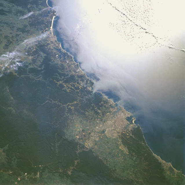 |
| STS61A-38-0011 Sydney and Newcastle Area, Australia November 1985 This northeast-looking, low-oblique photograph shows the southeast Australian coast from just north of Newcastle southwestward through Sydney to near Wollongong (south corner of the photograph). The forest-covered, dissected plateau of the Great Dividing Range, west of the coastal areas and bounded on the east by abrupt escarpments, acts as a barrier between the coastal regions and the vast plains of the interior of Australia. Sydney, the largest city in Australia and the capital of New South Wales (a tan-gray area south of Broken Bay near the center of the photograph), is blessed with one of the world's finest natural harbors. Sydney is Australia's chief port and its cultural and industrial center. The city has abundant port facilities with a large container terminal, shipyards, oil refineries, chemical plants, textile mills, brass foundries, automobile assembly plants, electronics equipment facilities, food processing plants, and an active tourism industry. Sydney, the first penal colony in Australia, was founded in 1788 just north of Botany Bay. Newcastle, 100 miles (161 kilometers) northeast of Sydney at the mouth of the Hunter River, is the center of the largest coal mining area in Australia. Major industries of Newcastle (south of a large, crescent-shaped, yellow beach area) include steel mills, shipyards, chemical plants, fertilizer plants, synthetic textile plants, and cotton processing plants. |
| Images: | All Available Images Low-Resolution 104k |
|
| Mission: | STS61A |
|
| Roll - Frame: | 38 - 11 |
|
| Geographical Name: | AUSTRALIA-NSW |
|
| Features: | SYDNEY, COASTLINE, SUNGLINT |
|
| Center Lat x Lon: | 33.5S x 151.0E |
|
| Film Exposure: | N | N=Normal exposure, U=Under exposed, O=Over exposed, F=out of Focus |
| Percentage of Cloud Cover-CLDP: | 5 |
|
| Camera:: | HB |
|
| Camera Tilt: | 30 | LO=Low Oblique, HO=High Oblique, NV=Near Vertical |
| Camera Focal Length: | 100 |
|
| Nadir to Photo Center Direction: | E | The direction from the nadir to the center point, N=North, S=South, E=East, W=West |
| Stereo?: | Y | Y=Yes there is an adjacent picture of the same area, N=No there isn't |
| Orbit Number: | 35 |
|
| Date: | 19851101 | YYYYMMDD |
| Time: | 215150 | GMT HHMMSS |
| Nadir Lat: | 33.8S |
Latitude of suborbital point of spacecraft |
| Nadir Lon: | 149.3E |
Longitude of suborbital point of spacecraft |
| Sun Azimuth: | 85 | Clockwise angle in degrees from north to the sun measured at the nadir point |
| Space Craft Altitude: | 180 | nautical miles |
| Sun Elevation: | 33 | Angle in degrees between the horizon and the sun, measured at the nadir point |
| Land Views: | MOUNTAIN, COAST, FOREST |
|
| Water Views: | BAY |
|
| Atmosphere Views: | |
|
| Man Made Views: | URBAN AREA |
|
| City Views: | SYDNEY |
|
Photo is not associated with any sequences | ||
| NASA Home Page |
JSC Home Page |
JSC Digital Image Collection |
Earth Science & Remote Sensing |
|
This service is provided by the International Space Station program and the JSC Earth Science & Remote Sensing Unit, ARES Division, Exploration Integration Science Directorate.

|