Geographic Region: MALAYSIA
Feature: TELOK BRUNEI
|
Geographic Region: MALAYSIA Feature: TELOK BRUNEI |
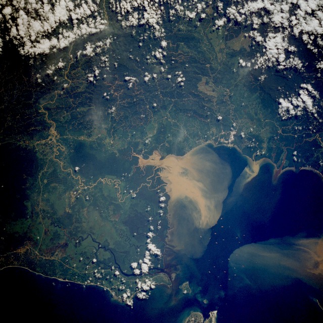 |
| STS61A-37-0076 Brunei Bay, Malaysia November 1985 This near-vertical photograph of the southwest coast of Sabah Province on the island of Borneo within the country of Malaysia vividly shows a huge sediment plume in the northeast corner of Brunei Bay, with smaller plumes entering from the south. The plume results from cutting rain forests and losing top soil with subsequent rains, a cycle that creates massive environmental damage in the former rain forest area. The course of the meandering, silt-laden Padas River can be traced into the interior as it passes through the remaining rain forest and the Crocker Mountain Range. The town of Beaufort is situated along the Padas River at the intersection of three highways. Numerous trails and roads (probably logging roads) are scattered throughout the eastern half of the photograph. Most of the land north of the large sediment plume is marsh and swampland; very little development appears in progress. Major highways help identify higher ground, especially along the coastal area. Inland from the smaller plumes, light green landscapes show no vegetation; perhaps plantations are being established. |
| Images: | Images: | NO IMAGES YET | |||
| Mission: | STS61A |
||||
| Roll - Frame: | 37 - 76 |
||||
| Geographical Name: | MALAYSIA |
||||
| Features: | TELOK BRUNEI |
||||
| Center Lat x Lon: | 5.0N x 115.5E |
||||
| Film Exposure: | N | N=Normal exposure, U=Under exposed, O=Over exposed, F=out of Focus |
|||
| Percentage of Cloud Cover-CLDP: | 20 |
||||
| Camera:: | HB |
||||
| Camera Tilt: | 20 | LO=Low Oblique, HO=High Oblique, NV=Near Vertical |
|||
| Camera Focal Length: | 250 |
||||
| Nadir to Photo Center Direction: | SW | The direction from the nadir to the center point, N=North, S=South, E=East, W=West |
|||
| Stereo?: | Y | Y=Yes there is an adjacent picture of the same area, N=No there isn't |
|||
| Orbit Number: | 23 |
||||
| Date: | 19851101 | YYYYMMDD |
|||
| Time: | 022030 | GMT HHMMSS |
|||
| Nadir Lat: | 5.9N |
Latitude of suborbital point of spacecraft | |||
| Nadir Lon: | 116.1E |
Longitude of suborbital point of spacecraft | |||
| Sun Azimuth: | 130 | Clockwise angle in degrees from north to the sun measured at the nadir point |
|||
| Space Craft Altitude: | 176 | nautical miles |
|||
| Sun Elevation: | 58 | Angle in degrees between the horizon and the sun, measured at the nadir point |
|||
| Land Views: | COAST, FOREST, PLAIN, PENINSULA, HILL |
||||
| Water Views: | RIVER, DELTA, BAY, SWAMP, SEDIMENT |
||||
| Atmosphere Views: | |
||||
| Man Made Views: | AGRICULTURE, DEFORESTATION |
||||
| City Views: | |
||||
Photo is not associated with any sequences | |||||
| NASA Home Page |
JSC Home Page |
JSC Digital Image Collection |
Earth Science & Remote Sensing |
|
This service is provided by the International Space Station program and the JSC Earth Science & Remote Sensing Unit, ARES Division, Exploration Integration Science Directorate.

|