Geographic Region: AUSTRALIA-WA
Feature: LAKE HINDS
|
Geographic Region: AUSTRALIA-WA Feature: LAKE HINDS |
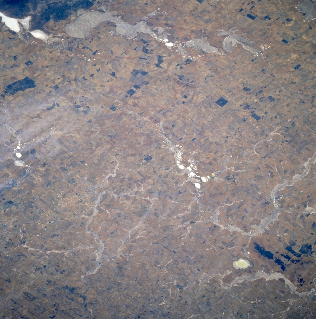 |
| STS61A-37-0018 Hinds (Dry) Lake, Western Australia, Australia November 1985 Several different looking dry lake beds and ephemeral stream channels are visible throughout the scene in this semiarid region northeast of Perth in southwestern Western Australia. Lake Hinds, the small, oval-shaped, light colored feature near the lower right corner of the picture, helps to locate the many drainage patterns north, northeast of the lake. These drainage features display at least three different color schemes and shapes that include highly reflective, whitish-looking areas to more subtle, partially vegetated surfaces that tends to blend into the surrounding landscape. A string of several, small dry lakes (small, round white areas) is observed near the center of the picture. The regular rectangular patterns surrounding the rivers and lakes are probably irrigated fields patterns, where some type of dry land farming is being practiced. |
| Images: | All Available Images Low-Resolution 361k |
|
| Mission: | STS61A |
|
| Roll - Frame: | 37 - 18 |
|
| Geographical Name: | AUSTRALIA-WA |
|
| Features: | LAKE HINDS |
|
| Center Lat x Lon: | 30.5S x 116.5E |
|
| Film Exposure: | N | N=Normal exposure, U=Under exposed, O=Over exposed, F=out of Focus |
| Percentage of Cloud Cover-CLDP: | 0 |
|
| Camera:: | HB |
|
| Camera Tilt: | 37 | LO=Low Oblique, HO=High Oblique, NV=Near Vertical |
| Camera Focal Length: | 250 |
|
| Nadir to Photo Center Direction: | NE | The direction from the nadir to the center point, N=North, S=South, E=East, W=West |
| Stereo?: | Y | Y=Yes there is an adjacent picture of the same area, N=No there isn't |
| Orbit Number: | 21 |
|
| Date: | 19851101 | YYYYMMDD |
| Time: | 003754 | GMT HHMMSS |
| Nadir Lat: | 31.8S |
Latitude of suborbital point of spacecraft |
| Nadir Lon: | 114.7E |
Longitude of suborbital point of spacecraft |
| Sun Azimuth: | 82 | Clockwise angle in degrees from north to the sun measured at the nadir point |
| Space Craft Altitude: | 179 | nautical miles |
| Sun Elevation: | 39 | Angle in degrees between the horizon and the sun, measured at the nadir point |
| Land Views: | PLAIN |
|
| Water Views: | LAKE |
|
| Atmosphere Views: | |
|
| Man Made Views: | |
|
| City Views: | |
|
Photo is not associated with any sequences | ||
| NASA Home Page |
JSC Home Page |
JSC Digital Image Collection |
Earth Science & Remote Sensing |
|
This service is provided by the International Space Station program and the JSC Earth Science & Remote Sensing Unit, ARES Division, Exploration Integration Science Directorate.

|