Geographic Region: CANADA-Q
Feature: CLEARWATER LAKES
|
Geographic Region: CANADA-Q Feature: CLEARWATER LAKES |
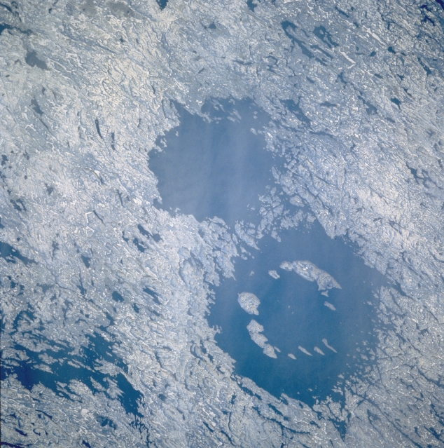 |
| STS61A-35-86 Clearwater Lakes, Quebec, Canada November 1985 These twin circular lakes (large dark features) were formed simultaneously by the impact of an asteroidal pair which slammed into the planet approximately 290 million years ago. The lakes are located near the eastern shore of Hudson Bay within the Canadian Shield in a region of generally low relief in northern Quebec province. Notice that the larger western structure contains a ring of islands that surrounds the center of the impact zone. The lakes are named after their exceedingly clear water. Also notice that the surrounding terrain shows widespread scarring from glaciation. The multitude of linear and irregular shaped lakes (dark features) are the result of gouging or scouring action caused by the continental ice sheets that once moved across this area. |
| Images: | All Available Images Low-Resolution 383k |
|
| Mission: | STS61A |
|
| Roll - Frame: | 35 - 86 |
|
| Geographical Name: | CANADA-Q |
|
| Features: | CLEARWATER LAKES |
|
| Center Lat x Lon: | 56.0N x 74.5W |
|
| Film Exposure: | N | N=Normal exposure, U=Under exposed, O=Over exposed, F=out of Focus |
| Percentage of Cloud Cover-CLDP: | 0 |
|
| Camera:: | HB |
|
| Camera Tilt: | 35 | LO=Low Oblique, HO=High Oblique, NV=Near Vertical |
| Camera Focal Length: | 250 |
|
| Nadir to Photo Center Direction: | W | The direction from the nadir to the center point, N=North, S=South, E=East, W=West |
| Stereo?: | Y | Y=Yes there is an adjacent picture of the same area, N=No there isn't |
| Orbit Number: | 34 |
|
| Date: | 19851101 | YYYYMMDD |
| Time: | 192044 | GMT HHMMSS |
| Nadir Lat: | 56.1N |
Latitude of suborbital point of spacecraft |
| Nadir Lon: | 72.4W |
Longitude of suborbital point of spacecraft |
| Sun Azimuth: | 221 | Clockwise angle in degrees from north to the sun measured at the nadir point |
| Space Craft Altitude: | 183 | nautical miles |
| Sun Elevation: | 11 | Angle in degrees between the horizon and the sun, measured at the nadir point |
| Land Views: | CRATER, HILL |
|
| Water Views: | LAKE |
|
| Atmosphere Views: | |
|
| Man Made Views: | |
|
| City Views: | |
|
Photo is not associated with any sequences | ||
| NASA Home Page |
JSC Home Page |
JSC Digital Image Collection |
Earth Science & Remote Sensing |
|
This service is provided by the International Space Station program and the JSC Earth Science & Remote Sensing Unit, ARES Division, Exploration Integration Science Directorate.

|