
Geographic Region: USA-NORTH DAKOTA
Feature: DEVILS LAKE
|
Geographic Region: USA-NORTH DAKOTA Feature: DEVILS LAKE |
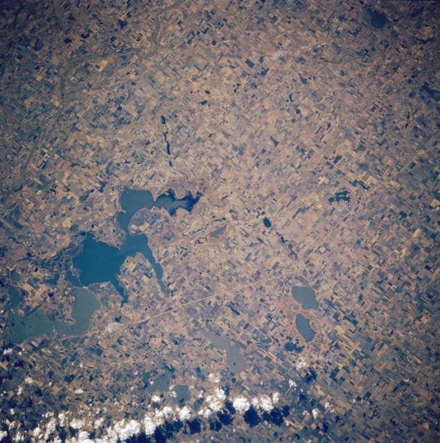 |
| STS61A-035-0080 Devils Lake, North Dakota, U.S.A. October 1985 This east-southeast-looking, low-oblique photograph shows the agricultural lands surrounding totally enclosed, saline Devils Lake. Because of no outlet, the lake's water levels, measured in terms of surface elevation, respond to changes in the climate--in cooler, wetter climates, lake levels rise; during warm, drier periods, levels decline. The surface elevation in 1880 was 1430 feet (436 meters); by 1940 it had dropped to 1401 feet (427 meters). With the decreased lake level, permanent settlement encroached further upon areas formerly occupied by water. Since 1940 water levels have gradually risen to present levels of near 1443 feet (440 meters), which have resulted in flooding of homes, highways, and municipal structures. Water surface elevation levels were near 1426 feet (435 meters) when this photograph was taken in 1985. Discernible north of the lake is U.S. Highway 2. The small city of Devils Lake on U.S. Highway 2 just north of the lake is barely perceptible. |
| Images: | All Available Images Low-Resolution 411k |
|
| Mission: | STS61A |
|
| Roll - Frame: | 35 - 80 |
|
| Geographical Name: | USA-NORTH DAKOTA |
|
| Features: | DEVILS LAKE |
|
| Center Lat x Lon: | 48.0N x 99W |
|
| Film Exposure: | N | N=Normal exposure, U=Under exposed, O=Over exposed, F=out of Focus |
| Percentage of Cloud Cover-CLDP: | 5 |
|
| Camera:: | HB |
|
| Camera Tilt: | 7 | LO=Low Oblique, HO=High Oblique, NV=Near Vertical |
| Camera Focal Length: | 250 |
|
| Nadir to Photo Center Direction: | SW | The direction from the nadir to the center point, N=North, S=South, E=East, W=West |
| Stereo?: | Y | Y=Yes there is an adjacent picture of the same area, N=No there isn't |
| Orbit Number: | 34 |
|
| Date: | 19851101 | YYYYMMDD |
| Time: | 191603 | GMT HHMMSS |
| Nadir Lat: | 48.3N |
Latitude of suborbital point of spacecraft |
| Nadir Lon: | 98.8W |
Longitude of suborbital point of spacecraft |
| Sun Azimuth: | 195 | Clockwise angle in degrees from north to the sun measured at the nadir point |
| Space Craft Altitude: | 181 | nautical miles |
| Sun Elevation: | 25 | Angle in degrees between the horizon and the sun, measured at the nadir point |
| Land Views: | PLAIN |
|
| Water Views: | LAKE |
|
| Atmosphere Views: | |
|
| Man Made Views: | AGRICULTURE |
|
| City Views: | |
|
Photo is not associated with any sequences | ||
| NASA Home Page |
JSC Home Page |
JSC Digital Image Collection |
Earth Science & Remote Sensing |
|
This service is provided by the International Space Station program and the JSC Earth Science & Remote Sensing Unit, ARES Division, Exploration Integration Science Directorate.

|