
Geographic Region: USA-NEW YORK
Feature: ADIRONDACK MOUNTAINS
|
Geographic Region: USA-NEW YORK Feature: ADIRONDACK MOUNTAINS |
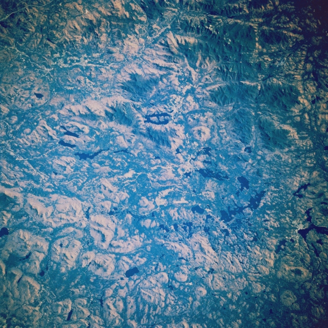 |
| STS61A-34-0023 Adirondack Mountains, Lake Placid, New York November 1985 The peculiar ladder-shaped Lake Placid (just above the center of the image) can be seen in this near-nadir view. Numerous forested hills, valleys, and lakes of the northeastern Adirondack Mountains are also visible. The shape of Lake Placid, as seen on the image, was formed many thousands of years ago by cris-crossing fracture zones, stream erosion, and glaciation. The lake is nearly 5 miles (8 km) long. The uplifted Adirondacks are new mountains, geologically speaking, carved from very old rocks nearly three billion years old. Eroded over the many years and sculptured by glaciers, the Adirondacks continue to rise at about 3 millimeters a year. The highland areas around Lake Placid, site of the 1932 and 1980 Winter Olympic Games, offers spectacular scenery and attracts many thousands of visitors every year. |
| Images: | All Available Images Low-Resolution 431k |
|
| Mission: | STS61A |
|
| Roll - Frame: | 34 - 23 |
|
| Geographical Name: | USA-NEW YORK |
|
| Features: | ADIRONDACK MOUNTAINS |
|
| Center Lat x Lon: | 44.5N x 74W |
|
| Film Exposure: | N | N=Normal exposure, U=Under exposed, O=Over exposed, F=out of Focus |
| Percentage of Cloud Cover-CLDP: | 0 |
|
| Camera:: | HB |
|
| Camera Tilt: | 14 | LO=Low Oblique, HO=High Oblique, NV=Near Vertical |
| Camera Focal Length: | 250 |
|
| Nadir to Photo Center Direction: | N | The direction from the nadir to the center point, N=North, S=South, E=East, W=West |
| Stereo?: | Y | Y=Yes there is an adjacent picture of the same area, N=No there isn't |
| Orbit Number: | 17 |
|
| Date: | 19851031 | YYYYMMDD |
| Time: | 172626 | GMT HHMMSS |
| Nadir Lat: | 43.8N |
Latitude of suborbital point of spacecraft |
| Nadir Lon: | 73.7W |
Longitude of suborbital point of spacecraft |
| Sun Azimuth: | 193 | Clockwise angle in degrees from north to the sun measured at the nadir point |
| Space Craft Altitude: | 180 | nautical miles |
| Sun Elevation: | 31 | Angle in degrees between the horizon and the sun, measured at the nadir point |
| Land Views: | MOUNTAIN, FOREST, FAULT |
|
| Water Views: | LAKE |
|
| Atmosphere Views: | |
|
| Man Made Views: | |
|
| City Views: | |
|
Photo is not associated with any sequences | ||
| NASA Home Page |
JSC Home Page |
JSC Digital Image Collection |
Earth Science & Remote Sensing |
|
This service is provided by the International Space Station program and the JSC Earth Science & Remote Sensing Unit, ARES Division, Exploration Integration Science Directorate.

|