
Geographic Region: USA-VERMONT
Feature: LAKE CHAMPLAIN
|
Geographic Region: USA-VERMONT Feature: LAKE CHAMPLAIN |
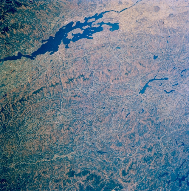 |
| STS61A-33-0048 Lake Champlain and Green Mountains, Vermont, U.S.A. November 1985 The forested Green Mountains, which extend from southwestern Quebec in Canada (right center) southward into northwest Massachusetts, are featured in this northwest-looking, low-oblique photograph. Containing some of the oldest rocks in North America; low, rounded peaks; fertile valleys; and many small streams, the Green Mountains are a vacation paradise with year-round resorts and recreational areas. Lake Champlain, 125 miles (201 kilometers) long and part of the Vermont-New York border, separates Vermont from the rugged Adirondack Mountains (upper left). Visible are three bodies of water--the Richelieu River, which drains Lake Champlain (right of upper center); large Lake Memphremagog, 30 miles (48 kilometers) long east of the Green Mountains (left center), which drains northward into the Saint Francis River in southern Quebec; and the Connecticut River, which separates Vermont and New Hampshire (bottom of photograph), east of which are the White Mountains of New Hampshire. |
| Images: | All Available Images Low-Resolution 432k |
|
| Mission: | STS61A |
|
| Roll - Frame: | 33 - 48 |
|
| Geographical Name: | USA-VERMONT |
|
| Features: | LAKE CHAMPLAIN |
|
| Center Lat x Lon: | 45.0N x 72.5W |
|
| Film Exposure: | N | N=Normal exposure, U=Under exposed, O=Over exposed, F=out of Focus |
| Percentage of Cloud Cover-CLDP: | 0 |
|
| Camera:: | HB |
|
| Camera Tilt: | 26 | LO=Low Oblique, HO=High Oblique, NV=Near Vertical |
| Camera Focal Length: | 100 |
|
| Nadir to Photo Center Direction: | NE | The direction from the nadir to the center point, N=North, S=South, E=East, W=West |
| Stereo?: | Y | Y=Yes there is an adjacent picture of the same area, N=No there isn't |
| Orbit Number: | 17 |
|
| Date: | 19851031 | YYYYMMDD |
| Time: | 172632 | GMT HHMMSS |
| Nadir Lat: | 43.9N |
Latitude of suborbital point of spacecraft |
| Nadir Lon: | 73.5W |
Longitude of suborbital point of spacecraft |
| Sun Azimuth: | 193 | Clockwise angle in degrees from north to the sun measured at the nadir point |
| Space Craft Altitude: | 180 | nautical miles |
| Sun Elevation: | 30 | Angle in degrees between the horizon and the sun, measured at the nadir point |
| Land Views: | MOUNTAIN, FOREST, FAULT |
|
| Water Views: | LAKE |
|
| Atmosphere Views: | |
|
| Man Made Views: | |
|
| City Views: | |
|
Photo is not associated with any sequences | ||
| NASA Home Page |
JSC Home Page |
JSC Digital Image Collection |
Earth Science & Remote Sensing |
|
This service is provided by the International Space Station program and the JSC Earth Science & Remote Sensing Unit, ARES Division, Exploration Integration Science Directorate.

|