
Geographic Region: USA-NEW YORK
Feature: LAKE CHAMPLAIN
|
Geographic Region: USA-NEW YORK Feature: LAKE CHAMPLAIN |
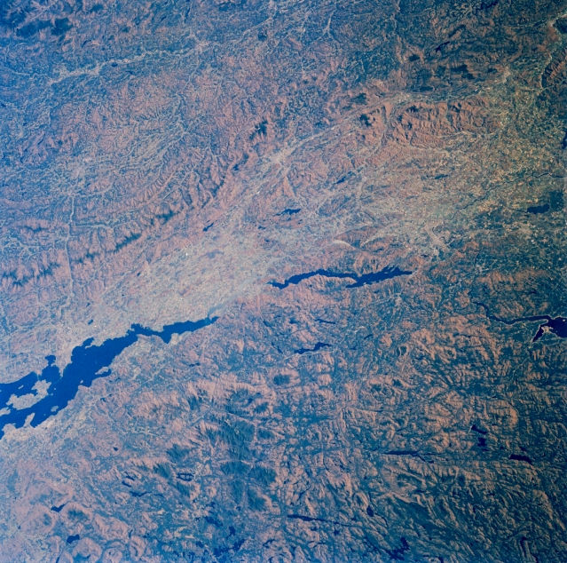 |
| STS61A-33-0046 Adirondack Mountains, Lake Champlain, and Green Mountains, New York and Vermont, U.S.A. November 1985 This east-southeast-looking, low-oblique photograph captures the southern half of Lake Champlain (midway between bottom left and left center) and the Lake Champlain Plain, which separates the Adirondack Mountains (lower half) of New York and the Green Mountains (upper half) of Vermont. Composed of some of the oldest rocks in North America, the Green Mountains of Vermont, a range of the Appalachians and a year-round resort and recreational area, have low, rounded peaks; fertile valleys; and many streams. Lake George, the center of a large resort and recreational region in the foothills of the Adirondacks, is 33 miles (53 kilometers) long and 1 to 3 miles (1 to 5 kilometers) wide. The lake and surrounding area were the location of many battles of the French and Indian War and the American Revolution. |
| Images: | All Available Images Low-Resolution 440k |
|
| Mission: | STS61A |
|
| Roll - Frame: | 33 - 46 |
|
| Geographical Name: | USA-NEW YORK |
|
| Features: | LAKE CHAMPLAIN |
|
| Center Lat x Lon: | 44.0N x 73.5W |
|
| Film Exposure: | N | N=Normal exposure, U=Under exposed, O=Over exposed, F=out of Focus |
| Percentage of Cloud Cover-CLDP: | 0 |
|
| Camera:: | HB |
|
| Camera Tilt: | 25 | LO=Low Oblique, HO=High Oblique, NV=Near Vertical |
| Camera Focal Length: | 100 |
|
| Nadir to Photo Center Direction: | NE | The direction from the nadir to the center point, N=North, S=South, E=East, W=West |
| Stereo?: | Y | Y=Yes there is an adjacent picture of the same area, N=No there isn't |
| Orbit Number: | 17 |
|
| Date: | 19851031 | YYYYMMDD |
| Time: | 172614 | GMT HHMMSS |
| Nadir Lat: | 43.1N |
Latitude of suborbital point of spacecraft |
| Nadir Lon: | 74.6W |
Longitude of suborbital point of spacecraft |
| Sun Azimuth: | 192 | Clockwise angle in degrees from north to the sun measured at the nadir point |
| Space Craft Altitude: | 180 | nautical miles |
| Sun Elevation: | 31 | Angle in degrees between the horizon and the sun, measured at the nadir point |
| Land Views: | MOUNTAIN, FAULT, VALLEY, FOREST |
|
| Water Views: | LAKE |
|
| Atmosphere Views: | |
|
| Man Made Views: | |
|
| City Views: | |
|
Photo is not associated with any sequences | ||
| NASA Home Page |
JSC Home Page |
JSC Digital Image Collection |
Earth Science & Remote Sensing |
|
This service is provided by the International Space Station program and the JSC Earth Science & Remote Sensing Unit, ARES Division, Exploration Integration Science Directorate.

|