
Geographic Region: USA-NEW YORK
Feature: ADIRONDACK MOUNTAINS
|
Geographic Region: USA-NEW YORK Feature: ADIRONDACK MOUNTAINS |
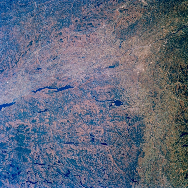 |
| STS61A-33-0045 Adirondack Mountains, Lakes George and Great Sacandaga, New York November 1985 This east-looking view shows the Mohawk River Valley extending generally eastward from Utica (lower right) to the Albany Plain and the Hudson River in the upper right portion of the image. The southeastern Adirondack Mountains cover the majority of the lower left quadrant of the image. The Green Mountains of southern Vermont and northwestern Massachusetts are visible in the upper left quadrant of the image. Two large lakes and the small portion of another are discernible on the image. Near the center of the image is the Great Sacandaga Lake that is 27 miles (43 km) long and covers an area of 42 sq. miles (109 sq. km). The long linear Lake George, which is located to the northeast of Great Sacandaga Lake, is 33 miles (53 km) long. Both lakes are popular resort and recreation areas. The extreme southern portion of Lake Champlain can be seen at the left center of the image. The capital city of New York, Albany which is located on the west bank of the Hudson River, is discernible in the upper left portion of the image. |
| Images: | All Available Images Low-Resolution 443k |
|
| Mission: | STS61A |
|
| Roll - Frame: | 33 - 45 |
|
| Geographical Name: | USA-NEW YORK |
|
| Features: | ADIRONDACK MOUNTAINS |
|
| Center Lat x Lon: | 43.5N x 74W |
|
| Film Exposure: | N | N=Normal exposure, U=Under exposed, O=Over exposed, F=out of Focus |
| Percentage of Cloud Cover-CLDP: | 0 |
|
| Camera:: | HB |
|
| Camera Tilt: | 27 | LO=Low Oblique, HO=High Oblique, NV=Near Vertical |
| Camera Focal Length: | 100 |
|
| Nadir to Photo Center Direction: | NE | The direction from the nadir to the center point, N=North, S=South, E=East, W=West |
| Stereo?: | Y | Y=Yes there is an adjacent picture of the same area, N=No there isn't |
| Orbit Number: | 17 |
|
| Date: | 19851031 | YYYYMMDD |
| Time: | 172604 | GMT HHMMSS |
| Nadir Lat: | 42.7N |
Latitude of suborbital point of spacecraft |
| Nadir Lon: | 75.3W |
Longitude of suborbital point of spacecraft |
| Sun Azimuth: | 191 | Clockwise angle in degrees from north to the sun measured at the nadir point |
| Space Craft Altitude: | 180 | nautical miles |
| Sun Elevation: | 32 | Angle in degrees between the horizon and the sun, measured at the nadir point |
| Land Views: | MOUNTAIN, FAULT, VALLEY, FOREST |
|
| Water Views: | LAKE, RIVER |
|
| Atmosphere Views: | |
|
| Man Made Views: | |
|
| City Views: | |
|
Photo is not associated with any sequences | ||
| NASA Home Page |
JSC Home Page |
JSC Digital Image Collection |
Earth Science & Remote Sensing |
|
This service is provided by the International Space Station program and the JSC Earth Science & Remote Sensing Unit, ARES Division, Exploration Integration Science Directorate.

|