
Geographic Region: CAMBODIA
Feature: MEKONG RIVER
|
Geographic Region: CAMBODIA Feature: MEKONG RIVER |
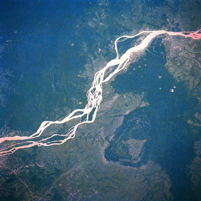 |
| STS61A-32-0030 Mekong River, Cambodia November 1985 The muddy Mekong River with its multiple intersecting stream channels extends southward (upper right to lower left) in this near vertical view of southeast Cambodia. The area covered in this image extends from just north of Kracheh to the Stoeng Treng area (upper right). This section of the Mekong passes largely through undeveloped jungle covered terrain. The dark topography (right center) along the upper east side of the river is a slightly elevated, densely forested landscape. STS61A-32-0029 shows another section of the Mekong River in Cambodia southwest of this scene and immediately northeast of Phnom Penh. |
| Images: | All Available Images Low-Resolution 417k |
|
| Mission: | STS61A |
|
| Roll - Frame: | 32 - 30 |
|
| Geographical Name: | CAMBODIA |
|
| Features: | MEKONG RIVER |
|
| Center Lat x Lon: | 13.5N x 106.0E |
|
| Film Exposure: | N | N=Normal exposure, U=Under exposed, O=Over exposed, F=out of Focus |
| Percentage of Cloud Cover-CLDP: | 0 |
|
| Camera:: | HB |
|
| Camera Tilt: | 21 | LO=Low Oblique, HO=High Oblique, NV=Near Vertical |
| Camera Focal Length: | 250 |
|
| Nadir to Photo Center Direction: | W | The direction from the nadir to the center point, N=North, S=South, E=East, W=West |
| Stereo?: | N | Y=Yes there is an adjacent picture of the same area, N=No there isn't |
| Orbit Number: | 8 |
|
| Date: | 19851031 | YYYYMMDD |
| Time: | 033646 | GMT HHMMSS |
| Nadir Lat: | 13.2N |
Latitude of suborbital point of spacecraft |
| Nadir Lon: | 107.1E |
Longitude of suborbital point of spacecraft |
| Sun Azimuth: | 151 | Clockwise angle in degrees from north to the sun measured at the nadir point |
| Space Craft Altitude: | 176 | nautical miles |
| Sun Elevation: | 59 | Angle in degrees between the horizon and the sun, measured at the nadir point |
| Land Views: | PLAIN, FOREST |
|
| Water Views: | RIVER |
|
| Atmosphere Views: | |
|
| Man Made Views: | |
|
| City Views: | |
|
Photo is not associated with any sequences | ||
| NASA Home Page |
JSC Home Page |
JSC Digital Image Collection |
Earth Science & Remote Sensing |
|
This service is provided by the International Space Station program and the JSC Earth Science & Remote Sensing Unit, ARES Division, Exploration Integration Science Directorate.

|