
Geographic Region: CAMBODIA
Feature: MEKONG RIVER, SUNGLINT
|
Geographic Region: CAMBODIA Feature: MEKONG RIVER, SUNGLINT |
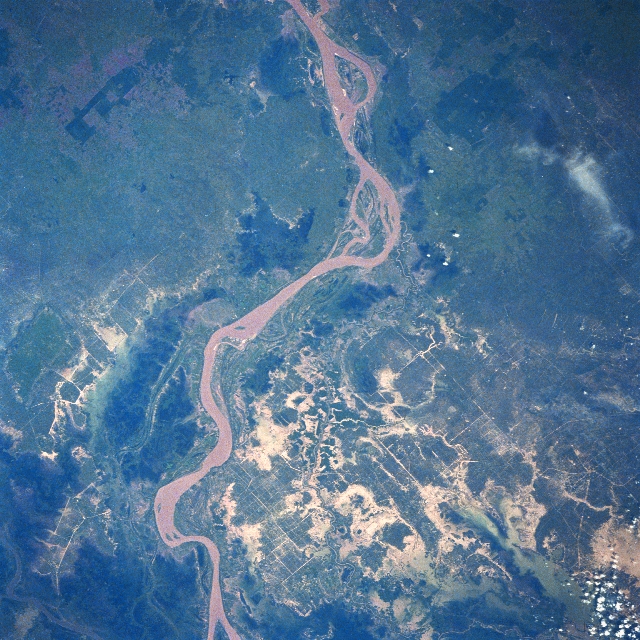 |
| STS61A-32-0029 Mekong River, Cambodia November 1985 A section of the muddy-looking Mekong River meanders through the low-lying, swampy terrain in south central Cambodia. This section of the Mekong drains from the northeast (upper center) to the southwest (lower center). The capital of Cambodia, Phnom Penh, is located along the west bank of the river, a few miles south of the bottom edge of the image. As seen in this image, the torrential rains that come with the wet summer-fall monsoons in this part of southeast Asia taxes the carrying capacity of the Mekong River. The rice fields south of the river reflect a high degree of flooding (numerous light-colored patterns bottom half of the image). The linear, intersecting lines are primarily irrigation canals that crisscross the rice producing landscape. The irregular-shaped, darker landscapes near the main channel of the Mekong are undeveloped, swampy areas, while the angular, dark patterns (upper third) are plantations. STS61A-32-0030 is another image of the Mekong River taken roughly 40 miles (64 km) northeast of this area in Cambodia. |
| Images: | All Available Images Low-Resolution 409k |
|
| Mission: | STS61A |
|
| Roll - Frame: | 32 - 29 |
|
| Geographical Name: | CAMBODIA |
|
| Features: | MEKONG RIVER, SUNGLINT |
|
| Center Lat x Lon: | 12.0N x 105.5E |
|
| Film Exposure: | N | N=Normal exposure, U=Under exposed, O=Over exposed, F=out of Focus |
| Percentage of Cloud Cover-CLDP: | 5 |
|
| Camera:: | HB |
|
| Camera Tilt: | 17 | LO=Low Oblique, HO=High Oblique, NV=Near Vertical |
| Camera Focal Length: | 250 |
|
| Nadir to Photo Center Direction: | W | The direction from the nadir to the center point, N=North, S=South, E=East, W=West |
| Stereo?: | N | Y=Yes there is an adjacent picture of the same area, N=No there isn't |
| Orbit Number: | 8 |
|
| Date: | 19851031 | YYYYMMDD |
| Time: | 033626 | GMT HHMMSS |
| Nadir Lat: | 12.1N |
Latitude of suborbital point of spacecraft |
| Nadir Lon: | 106.4E |
Longitude of suborbital point of spacecraft |
| Sun Azimuth: | 149 | Clockwise angle in degrees from north to the sun measured at the nadir point |
| Space Craft Altitude: | 176 | nautical miles |
| Sun Elevation: | 59 | Angle in degrees between the horizon and the sun, measured at the nadir point |
| Land Views: | PLAIN |
|
| Water Views: | RIVER, SUNGLINT, SWAMP |
|
| Atmosphere Views: | |
|
| Man Made Views: | |
|
| City Views: | |
|
Photo is not associated with any sequences | ||
| NASA Home Page |
JSC Home Page |
JSC Digital Image Collection |
Earth Science & Remote Sensing |
|
This service is provided by the International Space Station program and the JSC Earth Science & Remote Sensing Unit, ARES Division, Exploration Integration Science Directorate.

|