
Geographic Region: CRETE
Feature: COAST, EDDIES, SUNGLINT
|
Geographic Region: CRETE Feature: COAST, EDDIES, SUNGLINT |
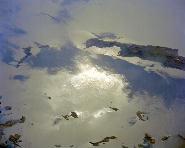 |
| STS61A-200-0046 Ocean Dynamics, Sea of Crete November 1985 Despite the underexposure of this southeast-looking photograph of the Sea of Crete and the small amount of information that can be gleaned from the islands (dark areas silhouetted against the water background), a camera-Sun relationship produced a phenomenon called sunglint. Sunglint is produced when a camera focuses on a water surface where light from the water surface reflects through the camera lens onto the film. Geometrically, this effect occurs only when the view focuses toward the Sun. The result of this interaction produces an image that can be used to analyze dynamic ocean features. Sea surface roughness determines the intensity or amount of reflected energy that is portrayed on the film--a smooth sea surface is more highly reflective than a rough sea, thereby producing areas on the film that are brighter. This sunglint photograph shows a tremendous amount of dynamic surface water detail--spiral eddies in the Sea of Crete north of the island of Crete, two very pronounced V-shaped ship wakes in the darker water off the northeast coast of Crete (indicative of ships traveling at high speeds through a rather calm sea), and island wakes around the smaller islands north of Crete. |
| Images: | All Available Images Low-Resolution 64k |
|
| Mission: | STS61A |
|
| Roll - Frame: | 200 - 46 |
|
| Geographical Name: | CRETE |
|
| Features: | COAST, EDDIES, SUNGLINT |
|
| Center Lat x Lon: | 35.5N x 26.0E |
|
| Film Exposure: | N | N=Normal exposure, U=Under exposed, O=Over exposed, F=out of Focus |
| Percentage of Cloud Cover-CLDP: | 10 |
|
| Camera:: | LH |
|
| Camera Tilt: | LO | LO=Low Oblique, HO=High Oblique, NV=Near Vertical |
| Camera Focal Length: | 250 |
|
| Nadir to Photo Center Direction: | The direction from the nadir to the center point, N=North, S=South, E=East, W=West |
|
| Stereo?: | Y | Y=Yes there is an adjacent picture of the same area, N=No there isn't |
| Orbit Number: | |
|
| Date: | 1985____ | YYYYMMDD |
| Time: | GMT HHMMSS |
|
| Nadir Lat: | N |
Latitude of suborbital point of spacecraft |
| Nadir Lon: | E |
Longitude of suborbital point of spacecraft |
| Sun Azimuth: | Clockwise angle in degrees from north to the sun measured at the nadir point |
|
| Space Craft Altitude: | nautical miles |
|
| Sun Elevation: | Angle in degrees between the horizon and the sun, measured at the nadir point |
|
| Land Views: | ISLAND |
|
| Water Views: | SEA, SUNGLINT, SHIP WAKE, SPIRAL EDDY |
|
| Atmosphere Views: | |
|
| Man Made Views: | |
|
| City Views: | |
|
Photo is not associated with any sequences | ||
| NASA Home Page |
JSC Home Page |
JSC Digital Image Collection |
Earth Science & Remote Sensing |
|
This service is provided by the International Space Station program and the JSC Earth Science & Remote Sensing Unit, ARES Division, Exploration Integration Science Directorate.

|