
Geographic Region: USA-ARIZONA
Feature: BLACK MESA, COLORADO R.
|
Geographic Region: USA-ARIZONA Feature: BLACK MESA, COLORADO R. |
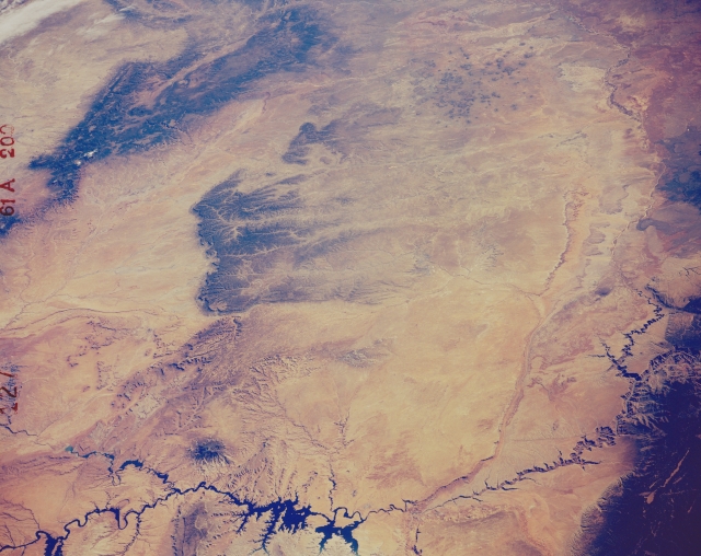 |
| STS61A-200-0127 Colorado Plateau, Arizona, U.S.A. November 1985 A synoptic view of the arid Colorado Plateau is captured in this southeast-looking photograph of northeastern Arizona from the deeply incised Colorado River as it passes through Marble Canyon to the dark Chuska Mountains that straddle the Arizona-New Mexico border. To the north (bottom of the photograph) Lake Powell and the Glen Canyon Dam area are visible. Most of the drainage features in this desert landscape consist of intermittently flowing streams (washes), one of which is the Little Colorado River. Other physical features include Navajo Mountain [a solitary peak 10 346 feet (3153 meters) above sea level], Black Mesa (the elevated plateau near the center of the photograph), Echo Cliffs (the linear feature toward the northwest side of the photograph in the lower right quadrant), and the Painted Desert (upper right corner). |
| Images: | All Available Images Low-Resolution 277k |
|
| Mission: | STS61A |
|
| Roll - Frame: | 200 - 127 |
|
| Geographical Name: | USA-ARIZONA |
|
| Features: | BLACK MESA, COLORADO R. |
|
| Center Lat x Lon: | 36.5N x 110.5W |
|
| Film Exposure: | N | N=Normal exposure, U=Under exposed, O=Over exposed, F=out of Focus |
| Percentage of Cloud Cover-CLDP: | 5 |
|
| Camera:: | LH |
|
| Camera Tilt: | LO | LO=Low Oblique, HO=High Oblique, NV=Near Vertical |
| Camera Focal Length: | 250 |
|
| Nadir to Photo Center Direction: | The direction from the nadir to the center point, N=North, S=South, E=East, W=West |
|
| Stereo?: | Y | Y=Yes there is an adjacent picture of the same area, N=No there isn't |
| Orbit Number: | |
|
| Date: | 1985____ | YYYYMMDD |
| Time: | GMT HHMMSS |
|
| Nadir Lat: | N |
Latitude of suborbital point of spacecraft |
| Nadir Lon: | E |
Longitude of suborbital point of spacecraft |
| Sun Azimuth: | Clockwise angle in degrees from north to the sun measured at the nadir point |
|
| Space Craft Altitude: | nautical miles |
|
| Sun Elevation: | Angle in degrees between the horizon and the sun, measured at the nadir point |
|
| Land Views: | MOUNTAIN, DESERT |
|
| Water Views: | RIVER, LAKE |
|
| Atmosphere Views: | |
|
| Man Made Views: | |
|
| City Views: | |
|
Photo is not associated with any sequences | ||
| NASA Home Page |
JSC Home Page |
JSC Digital Image Collection |
Earth Science & Remote Sensing |
|
This service is provided by the International Space Station program and the JSC Earth Science & Remote Sensing Unit, ARES Division, Exploration Integration Science Directorate.

|