
Geographic Region: USA-TEXAS
Feature: GALVESTON BAY, HOUSTON
|
Geographic Region: USA-TEXAS Feature: GALVESTON BAY, HOUSTON |
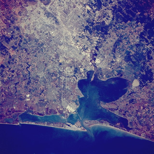 |
| STS51J-039-0056 Houston and Galveston, Texas, U.S.A. October 1985 The Houston and Galveston metropolitan areas appear in this northwest-looking, low-oblique photograph. Houston, the fourth most populous city in the United States and home of the NASA Lyndon B. Johnson Space Center, is a major oil center and a major commercial, medical, financial, and transportation hub along the Gulf of Mexico. The city has grown rapidly with the completion of the Houston Ship Channel in 1914 and is now the third-busiest port in the United States. From the center of the city Interstate Highway 45 extends southeastward to Galveston, which has major shipbuilding and ship repair facilities and is a major tourist area. Visible is Galveston Bay, a shallow inlet of the Gulf of Mexico. |
| Images: | All Available Images Low-Resolution 401k |
|
| Mission: | STS51J |
|
| Roll - Frame: | 39 - 56 |
|
| Geographical Name: | USA-TEXAS |
|
| Features: | GALVESTON BAY, HOUSTON |
|
| Center Lat x Lon: | 29.5N x 95W |
|
| Film Exposure: | N | N=Normal exposure, U=Under exposed, O=Over exposed, F=out of Focus |
| Percentage of Cloud Cover-CLDP: | 0 |
|
| Camera:: | HB |
|
| Camera Tilt: | 17 | LO=Low Oblique, HO=High Oblique, NV=Near Vertical |
| Camera Focal Length: | 250 |
|
| Nadir to Photo Center Direction: | N | The direction from the nadir to the center point, N=North, S=South, E=East, W=West |
| Stereo?: | Y | Y=Yes there is an adjacent picture of the same area, N=No there isn't |
| Orbit Number: | 17 |
|
| Date: | 19851004 | YYYYMMDD |
| Time: | 162809 | GMT HHMMSS |
| Nadir Lat: | 28.2N |
Latitude of suborbital point of spacecraft |
| Nadir Lon: | 94.8W |
Longitude of suborbital point of spacecraft |
| Sun Azimuth: | 139 | Clockwise angle in degrees from north to the sun measured at the nadir point |
| Space Craft Altitude: | 259 | nautical miles |
| Sun Elevation: | 49 | Angle in degrees between the horizon and the sun, measured at the nadir point |
| Land Views: | COAST, ISLAND, PLAIN |
|
| Water Views: | GULF, BAY, LAKE, RIVER |
|
| Atmosphere Views: | |
|
| Man Made Views: | HIGHWAY, AIRPORT, AGRICULTURE |
|
| City Views: | |
|
Photo is not associated with any sequences | ||
| NASA Home Page |
JSC Home Page |
JSC Digital Image Collection |
Earth Science & Remote Sensing |
|
This service is provided by the International Space Station program and the JSC Earth Science & Remote Sensing Unit, ARES Division, Exploration Integration Science Directorate.

|