
Geographic Region: BOLIVIA
Feature: LAGO POOPO
|
Geographic Region: BOLIVIA Feature: LAGO POOPO |
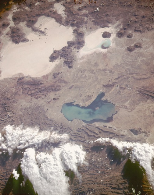 |
| STS51J-144-0023 Altiplano, Southwest Bolivia October 1985 Part of the high plateau known as the Altiplano in southwestern Bolivia, with average elevations exceeding 12 000 feet (3660 meters), is captured in this near-vertical photograph. The Altiplano is a sediment-filled depression that is bounded by the volcanic peaks of the Cordillera Occidental to the west and the folded mountain ranges of the Cordillera Oriental to the east. Numerous volcanoes, some with peaks exceeding 16 000 feet (4875 meters), are visible along the western edge of the photograph. The two large, highly reflective features are dry lake beds (salars) where salt has been deposited on the ground. The smaller, northernmost salt marsh is the Salar de Coipasa, and the larger, highly reflective surface is the Salar de Uyuni. Lake Poopó, the shallow lake whose depth never exceeds 15 feet (4.5 meters), displays a sediment plume dispersed throughout the lake. Although Lake Poopó receives some water from drainage along its southern end, the major water supply flows into the northern end of the lake via the intermittently flowing Desaguadero River, which connects Lake Titicaca with Lake Poopó. (Refer to STS-032-088-069, STS-073-735-047, STS-048-072-049, and STS-064-091-022 for additional information on Lake Poopó.) |
| Images: | All Available Images Low-Resolution 104k |
|
| Mission: | STS51J |
|
| Roll - Frame: | 144 - 23 |
|
| Geographical Name: | BOLIVIA |
|
| Features: | LAGO POOPO |
|
| Center Lat x Lon: | 19S x 67.5W |
|
| Film Exposure: | N | N=Normal exposure, U=Under exposed, O=Over exposed, F=out of Focus |
| Percentage of Cloud Cover-CLDP: | 20 |
|
| Camera:: | LH |
|
| Camera Tilt: | LO | LO=Low Oblique, HO=High Oblique, NV=Near Vertical |
| Camera Focal Length: | 250 |
|
| Nadir to Photo Center Direction: | The direction from the nadir to the center point, N=North, S=South, E=East, W=West |
|
| Stereo?: | N | Y=Yes there is an adjacent picture of the same area, N=No there isn't |
| Orbit Number: | |
|
| Date: | 198510__ | YYYYMMDD |
| Time: | GMT HHMMSS |
|
| Nadir Lat: | N |
Latitude of suborbital point of spacecraft |
| Nadir Lon: | E |
Longitude of suborbital point of spacecraft |
| Sun Azimuth: | Clockwise angle in degrees from north to the sun measured at the nadir point |
|
| Space Craft Altitude: | nautical miles |
|
| Sun Elevation: | Angle in degrees between the horizon and the sun, measured at the nadir point |
|
| Land Views: | BASIN, MOUNTAIN, PLATEAU, SALAR, VOLCANO |
|
| Water Views: | RIVER, SEDIMENT, LAKE |
|
| Atmosphere Views: | |
|
| Man Made Views: | |
|
| City Views: | |
|
Associated Photos in Sequence:  Photo #: STS057-99-65 Photo #: STS057-99-65Description: PERU/BOLIVIA-1993; L. TITICACA, L. POOPO REGION-SYNOPTIC VIEW Sequence ID: 6A  Photo #: SL3-115-1911 Photo #: SL3-115-1911Description: BOLIVIA, LAKE POOPO-1973; LAKE LEVEL Sequence ID: 6B  Photo #: STS51J-144-23 ** Currently displayed photo ** Photo #: STS51J-144-23 ** Currently displayed photo ** Description: BOLIVIA, LAKE POOPO-1985; LAKE LEVEL Sequence ID: 6C 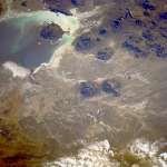 Photo #: STS026-40-64 Photo #: STS026-40-64Description: BOLIVIA, LAKE POOPO, LAKE COIPASA-1988; LAKE POOPO LAKE LEVEL Sequence ID: 6D  Photo #: STS032-88-69 Photo #: STS032-88-69Description: BOLIVIA, LAKE POOPO-1990; LAKE LEVEL Sequence ID: 6E  Photo #: STS048-72-49 Photo #: STS048-72-49Description: BOLIVIA, LAKE POOPO-1991; LAKE LEVEL CHANGES Sequence ID: 6F  Photo #: STS064-91-22 Photo #: STS064-91-22Description: BOLIVIA, LAKE POOPO-1994; DECREASING LAKE LEVEL Sequence ID: 6G  Photo #: STS073-735-47 Photo #: STS073-735-47Description: BOLIVIA, LAKE POOPO-1995; LAKE IS DRY Sequence ID: 6H | ||
| NASA Home Page |
JSC Home Page |
JSC Digital Image Collection |
Earth Science & Remote Sensing |
|
This service is provided by the International Space Station program and the JSC Earth Science & Remote Sensing Unit, ARES Division, Exploration Integration Science Directorate.

|