Geographic Region: EASTER ISLAND
Feature: EASTER ISLAND
|
Geographic Region: EASTER ISLAND Feature: EASTER ISLAND |
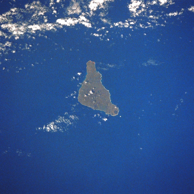 |
| STS51I-45-0054 Easter Island, Pacific Ocean August 1985 One of the most isolated inhabited islands in the world Easter Island is situated in the southern Pacific Ocean 2200 miles (3540 km) west of Chile. Easter Island, or Rapa Nui as it is sometimes referred, was formed by a series of massive volcanic eruptions. Until 1300 years ago, the island was inhabited by sea birds and was heavily forested with now extinct giant palm trees. Easter Island is roughly triangular and covers an area of 64 sq. miles (166 sq. km). Volcanic cones are found scattered across the island, but none have been active since the island was colonized 1300 years ago. Today, Easter Island, with its fertile volcanic soils, is covered with grasslands and is swept by strong trade winds. Farming is the principal occupation where sheep are raised, and maize, sweet potatoes, figs, bananas, pineapples, melons, and vegetables are grown. Easter Island is perhaps best known for its giant statues or Moai that were carved out of volcanic rock and are scattered in various places around the island. |
| Images: | All Available Images Low-Resolution 369k |
|
| Mission: | STS51I |
|
| Roll - Frame: | 45 - 54 |
|
| Geographical Name: | EASTER ISLAND |
|
| Features: | EASTER ISLAND |
|
| Center Lat x Lon: | 27S x 109.5W |
|
| Film Exposure: | N | N=Normal exposure, U=Under exposed, O=Over exposed, F=out of Focus |
| Percentage of Cloud Cover-CLDP: | 10 |
|
| Camera:: | HB |
|
| Camera Tilt: | 7 | LO=Low Oblique, HO=High Oblique, NV=Near Vertical |
| Camera Focal Length: | 250 |
|
| Nadir to Photo Center Direction: | SE | The direction from the nadir to the center point, N=North, S=South, E=East, W=West |
| Stereo?: | Y | Y=Yes there is an adjacent picture of the same area, N=No there isn't |
| Orbit Number: | 101 |
|
| Date: | 19850902 | YYYYMMDD |
| Time: | 204210 | GMT HHMMSS |
| Nadir Lat: | 26.7S |
Latitude of suborbital point of spacecraft |
| Nadir Lon: | 109.7W |
Longitude of suborbital point of spacecraft |
| Sun Azimuth: | 326 | Clockwise angle in degrees from north to the sun measured at the nadir point |
| Space Craft Altitude: | 189 | nautical miles |
| Sun Elevation: | 50 | Angle in degrees between the horizon and the sun, measured at the nadir point |
| Land Views: | ISLAND, VOLCANO |
|
| Water Views: | |
|
| Atmosphere Views: | |
|
| Man Made Views: | |
|
| City Views: | |
|
Photo is not associated with any sequences | ||
| NASA Home Page |
JSC Home Page |
JSC Digital Image Collection |
Earth Science & Remote Sensing |
|
This service is provided by the International Space Station program and the JSC Earth Science & Remote Sensing Unit, ARES Division, Exploration Integration Science Directorate.

|