
Geographic Region: MOZAMBIQUE CHANNEL
Feature: CURRENT BOUNDARY
|
Geographic Region: MOZAMBIQUE CHANNEL Feature: CURRENT BOUNDARY |
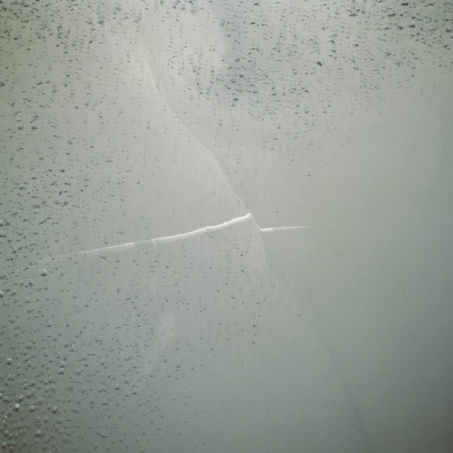 |
| STS51I-42-40 Suloy, Mozambique Channel August 1985 The faint, irregular-shaped line running east-west is a convergence of two currents in the Mozambique Channel between Madagascar and Africa. The blurred white line, offset where it crosses the current boundary, is a bilge-pumped ship wake that has been affected by the water movement along the boundary between water fronts. The resultant linear feature caused by the convergence of two water currents is called a suloy (a new oceanographic term). A suloy is an unusual condition of the sea in which the surface is covered by precipitous and irregular waves that form in lines at a convergence and in the curved boundaries of eddies. The term was coined by the Russians to describe such features in the White Sea. Few, if any, quantitative measurements have been made of a suloy, and there are no useful estimates of frequency and wave spectra or hypotheses of generation. There are fewer than a dozen published articles devoted to suloys, each of which is a description of a unique phenomenon. |
| Images: | All Available Images Low-Resolution 80k |
|
| Mission: | STS51I |
|
| Roll - Frame: | 42 - 40 |
|
| Geographical Name: | MOZAMBIQUE CHANNEL |
|
| Features: | CURRENT BOUNDARY |
|
| Center Lat x Lon: | N x E |
|
| Film Exposure: | N | N=Normal exposure, U=Under exposed, O=Over exposed, F=out of Focus |
| Percentage of Cloud Cover-CLDP: | 40 |
|
| Camera:: | HB |
|
| Camera Tilt: | LO=Low Oblique, HO=High Oblique, NV=Near Vertical |
|
| Camera Focal Length: | 250 |
|
| Nadir to Photo Center Direction: | The direction from the nadir to the center point, N=North, S=South, E=East, W=West |
|
| Stereo?: | N | Y=Yes there is an adjacent picture of the same area, N=No there isn't |
| Orbit Number: | 48 |
|
| Date: | 19850830 | YYYYMMDD |
| Time: | 112710 | GMT HHMMSS |
| Nadir Lat: | 22.5S |
Latitude of suborbital point of spacecraft |
| Nadir Lon: | 38.6E |
Longitude of suborbital point of spacecraft |
| Sun Azimuth: | 313 | Clockwise angle in degrees from north to the sun measured at the nadir point |
| Space Craft Altitude: | 172 | nautical miles |
| Sun Elevation: | 46 | Angle in degrees between the horizon and the sun, measured at the nadir point |
| Land Views: | |
|
| Water Views: | CHANNEL, SULOY, FRONT, SHIP WAKE |
|
| Atmosphere Views: | |
|
| Man Made Views: | |
|
| City Views: | |
|
Photo is not associated with any sequences | ||
| NASA Home Page |
JSC Home Page |
JSC Digital Image Collection |
Earth Science & Remote Sensing |
|
This service is provided by the International Space Station program and the JSC Earth Science & Remote Sensing Unit, ARES Division, Exploration Integration Science Directorate.

|