
Geographic Region: BOLIVIA
Feature: SANTA CRUZ
|
Geographic Region: BOLIVIA Feature: SANTA CRUZ |
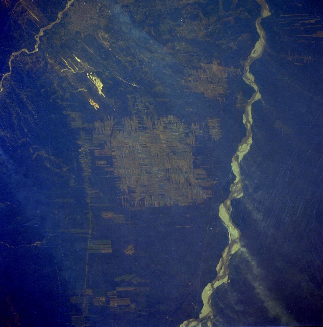 |
| STS51I-40-0071 Rio Grande, Bolivia September 1985 This near-vertical photograph of a rural landscape near Bolivia's second largest city of Santa Cruz is viewed through a hazy atmosphere. Santa Cruz, with a population of more than 500 000, is barely visible on the east side of the Rio Piray (near the northwestern corner of the photograph). To the west, the rugged foothills of the Andes Mountains begin their dramatic rise in elevation (not shown in this photograph). Southeast-trending patterns of sand and soil that have blown from the much larger, north-flowing Rio Grande are discernible on the eastern edge of the photograph. East of the Rio Grande an extensive area of undeveloped swamp and scrub woodlands extends to the Paraguay border; however, the lowland plain of east-central Bolivia shows extensive cultivated field patterns (center of the photograph) that probably provide commercial agricultural products. The very narrow, north-south-oriented features are railroads, pipelines, and highways that connect this region with the southern frontier of Bolivia. The northwest-southeast alignment of the highly reflective surfaces south and west of Santa Cruz are nonvegetated sand dunes that probably formed during an arid period. |
| Images: | All Available Images Low-Resolution 111k |
|
| Mission: | STS51I |
|
| Roll - Frame: | 40 - 71 |
|
| Geographical Name: | BOLIVIA |
|
| Features: | SANTA CRUZ |
|
| Center Lat x Lon: | 18S x 63W |
|
| Film Exposure: | N | N=Normal exposure, U=Under exposed, O=Over exposed, F=out of Focus |
| Percentage of Cloud Cover-CLDP: | 10 |
|
| Camera:: | HB |
|
| Camera Tilt: | 28 | LO=Low Oblique, HO=High Oblique, NV=Near Vertical |
| Camera Focal Length: | 250 |
|
| Nadir to Photo Center Direction: | N | The direction from the nadir to the center point, N=North, S=South, E=East, W=West |
| Stereo?: | Y | Y=Yes there is an adjacent picture of the same area, N=No there isn't |
| Orbit Number: | 52 |
|
| Date: | 19850830 | YYYYMMDD |
| Time: | 173046 | GMT HHMMSS |
| Nadir Lat: | 19.4S |
Latitude of suborbital point of spacecraft |
| Nadir Lon: | 63.6W |
Longitude of suborbital point of spacecraft |
| Sun Azimuth: | 324 | Clockwise angle in degrees from north to the sun measured at the nadir point |
| Space Craft Altitude: | 175 | nautical miles |
| Sun Elevation: | 56 | Angle in degrees between the horizon and the sun, measured at the nadir point |
| Land Views: | FOREST, PLAIN |
|
| Water Views: | RIVER, SEDIMENT |
|
| Atmosphere Views: | |
|
| Man Made Views: | DEFORESTATION, AGRICULTURE, URBAN AREA |
|
| City Views: | |
|
Photo is not associated with any sequences | ||
| NASA Home Page |
JSC Home Page |
JSC Digital Image Collection |
Earth Science & Remote Sensing |
|
This service is provided by the International Space Station program and the JSC Earth Science & Remote Sensing Unit, ARES Division, Exploration Integration Science Directorate.

|