
Geographic Region: AUSTRALIA-WA
Feature: LYONS RIVER
|
Geographic Region: AUSTRALIA-WA Feature: LYONS RIVER |
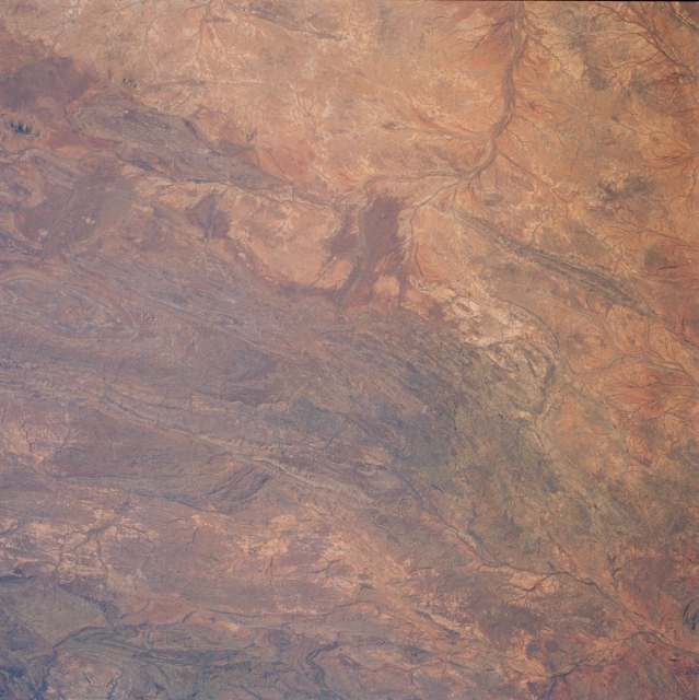 |
| STS51I-40-0027 Barlee and High Ranges, Western Australia, Australia August 1985 The darker landscape of this image shows the rugged and folded mountains of west central Western Australia (south of the Hamersly Ranges). Numerous low mountains are seen in this picture but lack of detailed topographic maps precludes a specific identification of individual mountain ranges. The High Range and the Barlee Range can be located because of their positions north and northeast of the Lyons River (top). The floodplain and several of the Lyons Rivers braided stream channels help to identify this river as it makes roughly a 90 degree course change (drains to northwest then southwest) in the upper middle part of the image. Other unidentified streams are visible as they cut through narrow valleys in the lower left and lower right corners of the image. All of the drainage features are ephemeral streams and rivers. |
| Images: | All Available Images Low-Resolution 326k |
|
| Mission: | STS51I |
|
| Roll - Frame: | 40 - 27 |
|
| Geographical Name: | AUSTRALIA-WA |
|
| Features: | LYONS RIVER |
|
| Center Lat x Lon: | 23.5S x 116.0E |
|
| Film Exposure: | N | N=Normal exposure, U=Under exposed, O=Over exposed, F=out of Focus |
| Percentage of Cloud Cover-CLDP: | 0 |
|
| Camera:: | HB |
|
| Camera Tilt: | 23 | LO=Low Oblique, HO=High Oblique, NV=Near Vertical |
| Camera Focal Length: | 100 |
|
| Nadir to Photo Center Direction: | NE | The direction from the nadir to the center point, N=North, S=South, E=East, W=West |
| Stereo?: | N | Y=Yes there is an adjacent picture of the same area, N=No there isn't |
| Orbit Number: | 45 |
|
| Date: | 19850830 | YYYYMMDD |
| Time: | 065423 | GMT HHMMSS |
| Nadir Lat: | 24.5S |
Latitude of suborbital point of spacecraft |
| Nadir Lon: | 115.3E |
Longitude of suborbital point of spacecraft |
| Sun Azimuth: | 306 | Clockwise angle in degrees from north to the sun measured at the nadir point |
| Space Craft Altitude: | 172 | nautical miles |
| Sun Elevation: | 39 | Angle in degrees between the horizon and the sun, measured at the nadir point |
| Land Views: | MOUNTAIN, FLOOD PLAIN |
|
| Water Views: | RIVER |
|
| Atmosphere Views: | |
|
| Man Made Views: | |
|
| City Views: | |
|
Photo is not associated with any sequences | ||
| NASA Home Page |
JSC Home Page |
JSC Digital Image Collection |
Earth Science & Remote Sensing |
|
This service is provided by the International Space Station program and the JSC Earth Science & Remote Sensing Unit, ARES Division, Exploration Integration Science Directorate.

|