Geographic Region: NAMIBIA
Feature: NAMIB DESERT
|
Geographic Region: NAMIBIA Feature: NAMIB DESERT |
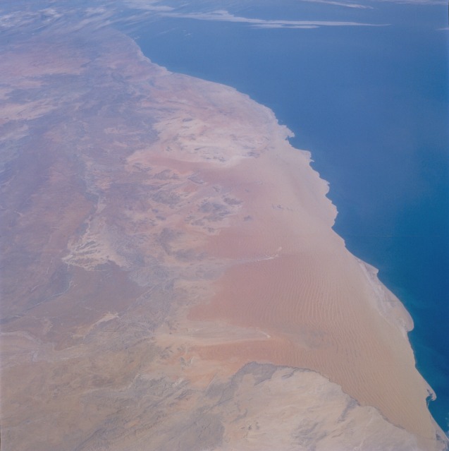 |
| STS51I-35-0003 Namib Desert, Namibia September 1985 The Namib Desert, for which the country of Namibia is named, is a classic example of a coastal desert along the southwestern side of a Southern Hemisphere continent. With a cold ocean current offshore, practically no natural conditions exist to produce any form of precipitation. Low, ground-hugging stratus clouds (fog) sometimes develop along the shoreline. When the fog moves onshore, it can provide the only form of moisture that parts of the Namib Desert receive for decades. This south-looking photograph shows two different physiographic provinces: a sand desert immediately adjacent to the Atlantic Ocean and a more diversified area of rocks and low hills inland. The sandy desert along the coast (known as the Skeleton Coast because it is part of the Namibia and Angola coastlines where numerous shipwrecks occurred during the last few centuries) consists of transverse dunes. A series of sand dunes parallel to one another was created by the wind blowing at right angles to the ridges. The windward (western) face has a more gentle slope, and the leeward (eastern) face tends to be steeper. The vertical distance between crest and trough can exceed 300 feet (90 meters). The entire region is so dry that no permanent watercourse flows from the higher elevations in the east to the Atlantic Ocean in the west. |
| Images: | All Available Images Low-Resolution 61k |
|
| Mission: | STS51I |
|
| Roll - Frame: | 35 - 3 |
|
| Geographical Name: | NAMIBIA |
|
| Features: | NAMIB DESERT |
|
| Center Lat x Lon: | 25S x 15.5E |
|
| Film Exposure: | N | N=Normal exposure, U=Under exposed, O=Over exposed, F=out of Focus |
| Percentage of Cloud Cover-CLDP: | 10 |
|
| Camera:: | HB |
|
| Camera Tilt: | LO | LO=Low Oblique, HO=High Oblique, NV=Near Vertical |
| Camera Focal Length: | 100 |
|
| Nadir to Photo Center Direction: | S | The direction from the nadir to the center point, N=North, S=South, E=East, W=West |
| Stereo?: | Y | Y=Yes there is an adjacent picture of the same area, N=No there isn't |
| Orbit Number: | 18 |
|
| Date: | 19850828 | YYYYMMDD |
| Time: | 133639 | GMT HHMMSS |
| Nadir Lat: | 20.3S |
Latitude of suborbital point of spacecraft |
| Nadir Lon: | 15.2E |
Longitude of suborbital point of spacecraft |
| Sun Azimuth: | 304 | Clockwise angle in degrees from north to the sun measured at the nadir point |
| Space Craft Altitude: | 191 | nautical miles |
| Sun Elevation: | 41 | Angle in degrees between the horizon and the sun, measured at the nadir point |
| Land Views: | DESERT, DUNE, COAST, PLATEAU |
|
| Water Views: | OCEAN |
|
| Atmosphere Views: | |
|
| Man Made Views: | |
|
| City Views: | |
|
Photo is not associated with any sequences | ||
| NASA Home Page |
JSC Home Page |
JSC Digital Image Collection |
Earth Science & Remote Sensing |
|
This service is provided by the International Space Station program and the JSC Earth Science & Remote Sensing Unit, ARES Division, Exploration Integration Science Directorate.

|