Geographic Region: GUYANA
Feature: GEORGETOWN
|
Geographic Region: GUYANA Feature: GEORGETOWN |
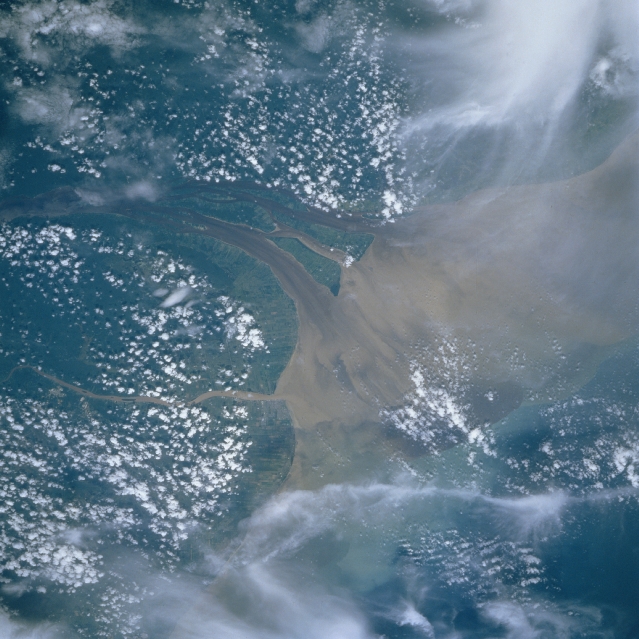 |
| STS51I-31-0093 Georgetown, Essequibo River Mouth, Guyana August 1985 The mouth of the sediment-laden Essequibo River is visible in this west-looking view. The Essequibo River, the longest river in Guyana at 600 miles (995 km) long, rises in the Guiana Highlands near the Brazilian border. The river flows northward to the Atlantic Ocean and there are rapids and waterfalls along most of its course. East of the Essequibo is the smaller Demerara River (near center of image), which is 200 miles (320 km) long and rises in the Guiana Highlands of eastern Guyana. The river is navigable for ocean-going vessels inland to the port city of Mackenzie (not visible on image), an important exporting center for bauxite and kaolin. Georgetown, the capital city of Guyana, is on the east bank of the Demerara River at the Atlantic seacoast. |
| Images: | All Available Images Low-Resolution 324k |
|
| Mission: | STS51I |
|
| Roll - Frame: | 31 - 93 |
|
| Geographical Name: | GUYANA |
|
| Features: | GEORGETOWN |
|
| Center Lat x Lon: | 7.0N x 58.5W |
|
| Film Exposure: | N | N=Normal exposure, U=Under exposed, O=Over exposed, F=out of Focus |
| Percentage of Cloud Cover-CLDP: | 70 |
|
| Camera:: | HB |
|
| Camera Tilt: | 37 | LO=Low Oblique, HO=High Oblique, NV=Near Vertical |
| Camera Focal Length: | 250 |
|
| Nadir to Photo Center Direction: | E | The direction from the nadir to the center point, N=North, S=South, E=East, W=West |
| Stereo?: | N | Y=Yes there is an adjacent picture of the same area, N=No there isn't |
| Orbit Number: | 19 |
|
| Date: | 19850828 | YYYYMMDD |
| Time: | 145231 | GMT HHMMSS |
| Nadir Lat: | 7.5N |
Latitude of suborbital point of spacecraft |
| Nadir Lon: | 60.9W |
Longitude of suborbital point of spacecraft |
| Sun Azimuth: | 81 | Clockwise angle in degrees from north to the sun measured at the nadir point |
| Space Craft Altitude: | 195 | nautical miles |
| Sun Elevation: | 71 | Angle in degrees between the horizon and the sun, measured at the nadir point |
| Land Views: | COAST |
|
| Water Views: | RIVER, DELTA, SEDIMENT |
|
| Atmosphere Views: | |
|
| Man Made Views: | |
|
| City Views: | |
|
Photo is not associated with any sequences | ||
| NASA Home Page |
JSC Home Page |
JSC Digital Image Collection |
Earth Science & Remote Sensing |
|
This service is provided by the International Space Station program and the JSC Earth Science & Remote Sensing Unit, ARES Division, Exploration Integration Science Directorate.

|