Geographic Region: NAMIBIA
Feature: ETOSHA PAN, OVAMBOLAND
|
Geographic Region: NAMIBIA Feature: ETOSHA PAN, OVAMBOLAND |
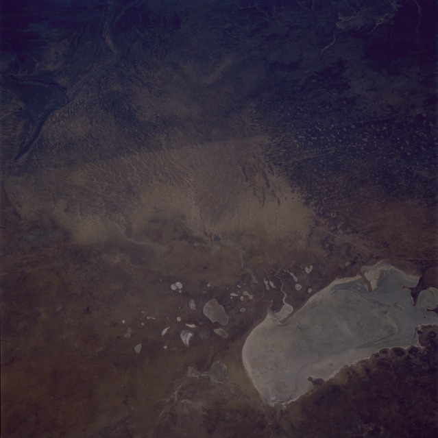 |
| STS51G-046-0078 Etosha Pan, Namibia June 1985 Only occasionally are country boundaries easily observed from space. In this near-vertical photograph, the straight border between Angola (north) and Namibia (south) is clear. The major cause of this marked difference in terrain is that the two countries have different livestock grazing practices. Obviously, Namibia has allowed more grazing to take place; hence, there is less vegetation, resulting in highly reflective soil, which is recorded in this photograph. The large, relatively rectangular, and highly reflective landform in the southeastern part of the photograph is a dry lakebed known as the Etosha [salt] Pan. Notice that several highly reflective dry lakes lie to the northwest of the much larger Etosha Pan dry lake. In this semiarid environment, only on rare occasions is there any evidence of moisture or surface runoff into these dry lakebeds. |
| Images: | All Available Images Low-Resolution 72k |
|
| Mission: | STS51G |
|
| Roll - Frame: | 46 - 78 |
|
| Geographical Name: | NAMIBIA |
|
| Features: | ETOSHA PAN, OVAMBOLAND |
|
| Center Lat x Lon: | 17.9S x 15.6E |
|
| Film Exposure: | N | N=Normal exposure, U=Under exposed, O=Over exposed, F=out of Focus |
| Percentage of Cloud Cover-CLDP: | 0 |
|
| Camera:: | HB |
|
| Camera Tilt: | 41 | LO=Low Oblique, HO=High Oblique, NV=Near Vertical |
| Camera Focal Length: | 100 |
|
| Nadir to Photo Center Direction: | N | The direction from the nadir to the center point, N=North, S=South, E=East, W=West |
| Stereo?: | N | Y=Yes there is an adjacent picture of the same area, N=No there isn't |
| Orbit Number: | 33 |
|
| Date: | 19850619 | YYYYMMDD |
| Time: | 130455 | GMT HHMMSS |
| Nadir Lat: | 20.7S |
Latitude of suborbital point of spacecraft |
| Nadir Lon: | 16.1E |
Longitude of suborbital point of spacecraft |
| Sun Azimuth: | 322 | Clockwise angle in degrees from north to the sun measured at the nadir point |
| Space Craft Altitude: | 194 | nautical miles |
| Sun Elevation: | 36 | Angle in degrees between the horizon and the sun, measured at the nadir point |
| Land Views: | BASIN, DESERT |
|
| Water Views: | LAKE, RIVER |
|
| Atmosphere Views: | |
|
| Man Made Views: | AGRICULTURE |
|
| City Views: | |
|
Photo is not associated with any sequences | ||
| NASA Home Page |
JSC Home Page |
JSC Digital Image Collection |
Earth Science & Remote Sensing |
|
This service is provided by the International Space Station program and the JSC Earth Science & Remote Sensing Unit, ARES Division, Exploration Integration Science Directorate.

|