
Geographic Region: ATLANTIC OCEAN
Feature: SQUALL LINES-CLOUDS
|
Geographic Region: ATLANTIC OCEAN Feature: SQUALL LINES-CLOUDS |
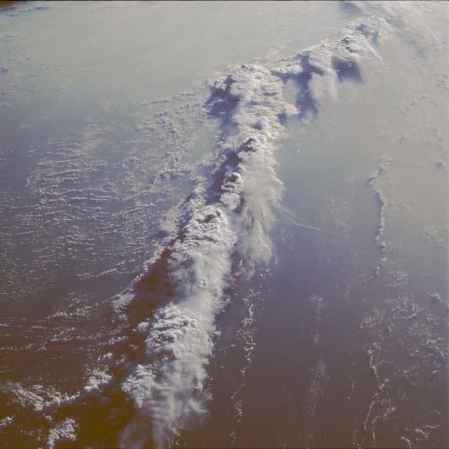 |
| STS51G-046-0005 Squall Line, Atlantic Ocean June 1985 A string of thunderstorms, or squall line, is visible in this low-oblique, south-looking photograph taken over the Atlantic Ocean just southeast of Bermuda. A squall line can be severe, causing high winds, torrential rainfall, and possible tornadoes. The passing squall line marks the replacement of warm moist air with cooler, drier air. When a cold front progresses eastward off the east coast of the United States, a narrow band of convective thunderstorms often continues eastward across the Atlantic Ocean. These thunderstorms can be intense, rising to heights in excess of 40 000 feet (12 200 meters) as seen in this photograph. While these storms pose no threat to land, they are of great concern to marine interests because of the potential development of strong gusty winds, heavy rainfall, and waterspouts. |
| Images: | All Available Images Low-Resolution 104k |
|
| Mission: | STS51G |
|
| Roll - Frame: | 46 - 5 |
|
| Geographical Name: | ATLANTIC OCEAN |
|
| Features: | SQUALL LINES-CLOUDS |
|
| Center Lat x Lon: | N x E |
|
| Film Exposure: | N | N=Normal exposure, U=Under exposed, O=Over exposed, F=out of Focus |
| Percentage of Cloud Cover-CLDP: | 40 |
|
| Camera:: | HB |
|
| Camera Tilt: | LO | LO=Low Oblique, HO=High Oblique, NV=Near Vertical |
| Camera Focal Length: | 100 |
|
| Nadir to Photo Center Direction: | The direction from the nadir to the center point, N=North, S=South, E=East, W=West |
|
| Stereo?: | Y | Y=Yes there is an adjacent picture of the same area, N=No there isn't |
| Orbit Number: | 31 |
|
| Date: | 19850619 | YYYYMMDD |
| Time: | 092739 | GMT HHMMSS |
| Nadir Lat: | 28.4N |
Latitude of suborbital point of spacecraft |
| Nadir Lon: | 56.3W |
Longitude of suborbital point of spacecraft |
| Sun Azimuth: | 67 | Clockwise angle in degrees from north to the sun measured at the nadir point |
| Space Craft Altitude: | 204 | nautical miles |
| Sun Elevation: | 6 | Angle in degrees between the horizon and the sun, measured at the nadir point |
| Land Views: | |
|
| Water Views: | OCEAN |
|
| Atmosphere Views: | THUNDERSTORM, SQUALL LINE |
|
| Man Made Views: | |
|
| City Views: | |
|
Photo is not associated with any sequences | ||
| NASA Home Page |
JSC Home Page |
JSC Digital Image Collection |
Earth Science & Remote Sensing |
|
This service is provided by the International Space Station program and the JSC Earth Science & Remote Sensing Unit, ARES Division, Exploration Integration Science Directorate.

|