Geographic Region: SUDAN
Feature: AL BAHR AL ABYAD, NILE R
|
Geographic Region: SUDAN Feature: AL BAHR AL ABYAD, NILE R |
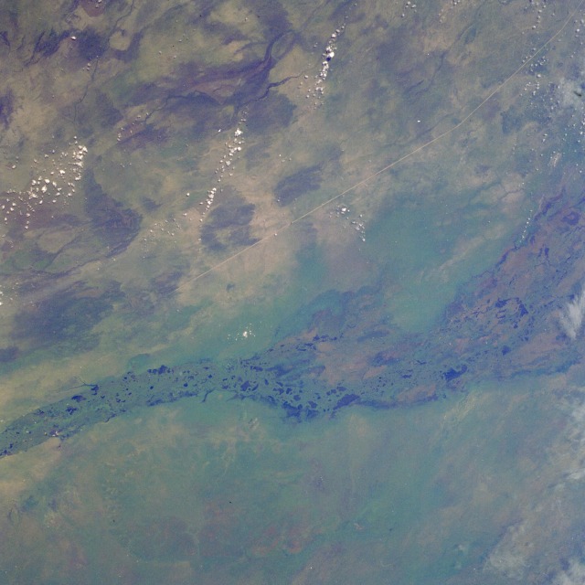 |
| STS51G-046-0001 Sudd Swamp, Sudan June 1985 The Sudd Swamp, a huge environmentally sensitive wetlands area of south-central Sudan, is seen in this photograph that shows only a part of the snarl of lakes, channels, and marshes that covers the region. The Sudd's areal extent varies from approximately 6370 square miles (16 500 square kilometers) in the dry winter season to 12 350 square miles (32 000 square kilometers) during the summer rains. The western branch of the Nile River, the White Nile, provides most of the water for this region. Initially, the word "sudd" was used to describe the great mass of floating, swampy vegetation that covers this region and tends to choke the waterflow through the main channel of the White Nile. The vegetation does function as a stabilizing influence on the rate of waterflow through the swamp. Two major features are visible--the natural attribute is the main channel of the north-flowing White Nile, which can be seen despite the lush, green vegetation that obscures most of the water surface of the river, and the manmade structure is the Jonglei Canal, which is linear, highly reflective, and aligned north-south. The canal is approximately 210 feet (65 meters) wide and has an average depth of 16 feet (5 meters). During the last two decades, the Jonglei Canal has become a controversial engineering project in this part of Africa--to the extent that a civil war curtailed its completion. The purpose for the canal was to help regulate the seasonal fluctuations in this segment of the White Nile and to drain part of the Sudd for agricultural development. Environmentalists and the local farmers proclaim that the construction of the Jonglei Canal upsets the natural rhythm of plants and animals whose migration cycles are impeded by the barrier the canal creates. |
| Images: | All Available Images Low-Resolution 98k |
|
| Mission: | STS51G |
|
| Roll - Frame: | 46 - 1 |
|
| Geographical Name: | SUDAN |
|
| Features: | AL BAHR AL ABYAD, NILE R |
|
| Center Lat x Lon: | 7.1N x 31.1E |
|
| Film Exposure: | U | N=Normal exposure, U=Under exposed, O=Over exposed, F=out of Focus |
| Percentage of Cloud Cover-CLDP: | 5 |
|
| Camera:: | HB |
|
| Camera Tilt: | 31 | LO=Low Oblique, HO=High Oblique, NV=Near Vertical |
| Camera Focal Length: | 100 |
|
| Nadir to Photo Center Direction: | W | The direction from the nadir to the center point, N=North, S=South, E=East, W=West |
| Stereo?: | Y | Y=Yes there is an adjacent picture of the same area, N=No there isn't |
| Orbit Number: | 30 |
|
| Date: | 19850619 | YYYYMMDD |
| Time: | 081341 | GMT HHMMSS |
| Nadir Lat: | 7.2N |
Latitude of suborbital point of spacecraft |
| Nadir Lon: | 33.1E |
Longitude of suborbital point of spacecraft |
| Sun Azimuth: | 51 | Clockwise angle in degrees from north to the sun measured at the nadir point |
| Space Craft Altitude: | 197 | nautical miles |
| Sun Elevation: | 62 | Angle in degrees between the horizon and the sun, measured at the nadir point |
| Land Views: | PLAIN |
|
| Water Views: | SWAMP, RIVER, CHANNEL |
|
| Atmosphere Views: | |
|
| Man Made Views: | |
|
| City Views: | |
|
Photo is not associated with any sequences | ||
| NASA Home Page |
JSC Home Page |
JSC Digital Image Collection |
Earth Science & Remote Sensing |
|
This service is provided by the International Space Station program and the JSC Earth Science & Remote Sensing Unit, ARES Division, Exploration Integration Science Directorate.

|