Geographic Region: ECUADOR
Feature: GUAYAQUIL, RIO GUAYAS
|
Geographic Region: ECUADOR Feature: GUAYAQUIL, RIO GUAYAS |
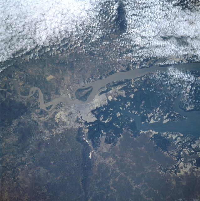 |
| STS51G-38-0043 Guayaquil, Ecuador June 1985 The largest city in Ecuador, Guayaquil, can be seen in this near-nadir view (north to left). Guayaquil is a bustling city combining the functions of a national port and manufacturing center, with good road and rail links to most of Ecuador. With the capture of Guayaquil from Spanish forces in 1821 and with Ecuador gaining independence from Spain shortly thereafter, the city began to grow in strategic and economic importance. The sediment-laden Guayas River spans the center of the image, and Santay Island is near the center of the view. A 33 foot (10 meter) deep channel is maintained from the comparatively sediment free Salado estuary (at right center) to the Gulf of Guayaquil and the Pacific Ocean, about 43 miles (70 km) from the Guayaquil's port facilities to the south of the city. Clouds cover the broad, poorly drained lowlands east of the city (upper portion of image). The low-flat-topped Blue Hills are discernible to the west of the city (bottom left). |
| Images: | All Available Images Low-Resolution 362k |
|
| Mission: | STS51G |
|
| Roll - Frame: | 38 - 43 |
|
| Geographical Name: | ECUADOR |
|
| Features: | GUAYAQUIL, RIO GUAYAS |
|
| Center Lat x Lon: | 2.5S x 80W |
|
| Film Exposure: | U | N=Normal exposure, U=Under exposed, O=Over exposed, F=out of Focus |
| Percentage of Cloud Cover-CLDP: | 20 |
|
| Camera:: | HB |
|
| Camera Tilt: | 22 | LO=Low Oblique, HO=High Oblique, NV=Near Vertical |
| Camera Focal Length: | 250 |
|
| Nadir to Photo Center Direction: | W | The direction from the nadir to the center point, N=North, S=South, E=East, W=West |
| Stereo?: | N | Y=Yes there is an adjacent picture of the same area, N=No there isn't |
| Orbit Number: | 97 |
|
| Date: | 19850623 | YYYYMMDD |
| Time: | 143302 | GMT HHMMSS |
| Nadir Lat: | 2.4S |
Latitude of suborbital point of spacecraft |
| Nadir Lon: | 78.9W |
Longitude of suborbital point of spacecraft |
| Sun Azimuth: | 54 | Clockwise angle in degrees from north to the sun measured at the nadir point |
| Space Craft Altitude: | 165 | nautical miles |
| Sun Elevation: | 42 | Angle in degrees between the horizon and the sun, measured at the nadir point |
| Land Views: | PLAIN, HILL |
|
| Water Views: | RIVER, SEDIMENT |
|
| Atmosphere Views: | |
|
| Man Made Views: | URBAN AREA |
|
| City Views: | |
|
Photo is not associated with any sequences | ||
| NASA Home Page |
JSC Home Page |
JSC Digital Image Collection |
Earth Science & Remote Sensing |
|
This service is provided by the International Space Station program and the JSC Earth Science & Remote Sensing Unit, ARES Division, Exploration Integration Science Directorate.

|