
Geographic Region: HAITI
Feature: PORT-AU-PRINCE, BAY
|
Geographic Region: HAITI Feature: PORT-AU-PRINCE, BAY |
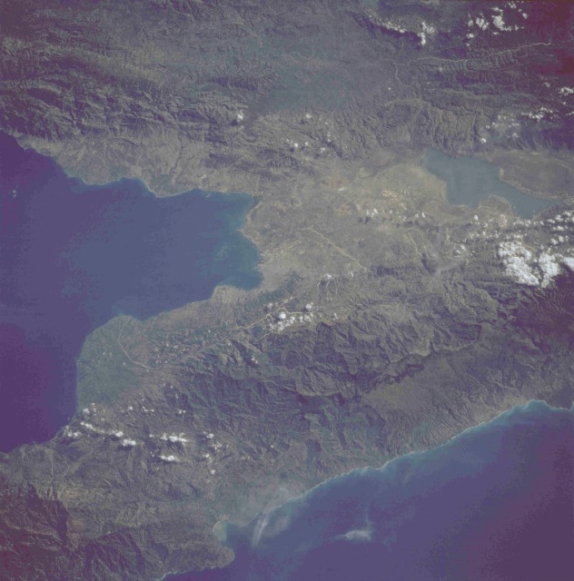 |
| STS51G-036-0063 Port-au-Prince Area, Haiti June 1985 The leading seaport and capital city of Haiti, Port-au-Prince, can be seen in the center of this photograph. The two rugged and complex major mountain ranges (one range extending in an east-west direction south of the city and the second range generally aligned in a northwest-southeast direction north of the city) are separated by a structural depression known as the Enriquillo Cul de Sac. Elevations above sea level in these two ranges exceed 5000 feet (1500 meters) in the northern range and 7000 feet (2100 meters) in the southern range. The large lake east of Port-au-Prince, known as Etang Saumatre, is brackish and was formed as a result of a downfaulted block between the two mountain ranges. |
| Images: | All Available Images Low-Resolution 102k |
|
| Mission: | STS51G |
|
| Roll - Frame: | 36 - 63 |
|
| Geographical Name: | HAITI |
|
| Features: | PORT-AU-PRINCE, BAY |
|
| Center Lat x Lon: | 18.5N x 72.3W |
|
| Film Exposure: | U | N=Normal exposure, U=Under exposed, O=Over exposed, F=out of Focus |
| Percentage of Cloud Cover-CLDP: | 10 |
|
| Camera:: | HB |
|
| Camera Tilt: | 21 | LO=Low Oblique, HO=High Oblique, NV=Near Vertical |
| Camera Focal Length: | 250 |
|
| Nadir to Photo Center Direction: | N | The direction from the nadir to the center point, N=North, S=South, E=East, W=West |
| Stereo?: | N | Y=Yes there is an adjacent picture of the same area, N=No there isn't |
| Orbit Number: | 49 |
|
| Date: | 19850620 | YYYYMMDD |
| Time: | 131208 | GMT HHMMSS |
| Nadir Lat: | 17.2N |
Latitude of suborbital point of spacecraft |
| Nadir Lon: | 72.5W |
Longitude of suborbital point of spacecraft |
| Sun Azimuth: | 73 | Clockwise angle in degrees from north to the sun measured at the nadir point |
| Space Craft Altitude: | 205 | nautical miles |
| Sun Elevation: | 38 | Angle in degrees between the horizon and the sun, measured at the nadir point |
| Land Views: | FAULT, BASIN, MOUNTAIN |
|
| Water Views: | LAKE, BAY |
|
| Atmosphere Views: | |
|
| Man Made Views: | AGRICULTURE, URBAN AREA |
|
| City Views: | |
|
Photo is not associated with any sequences | ||
| NASA Home Page |
JSC Home Page |
JSC Digital Image Collection |
Earth Science & Remote Sensing |
|
This service is provided by the International Space Station program and the JSC Earth Science & Remote Sensing Unit, ARES Division, Exploration Integration Science Directorate.

|