
Geographic Region: VENEZUELA
Feature: GULF VENEZUELA,PARAGUANA
|
Geographic Region: VENEZUELA Feature: GULF VENEZUELA,PARAGUANA |
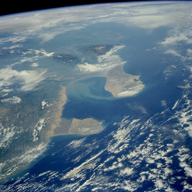 |
| STS51G-035-0038 Gulf of Venezuela Region, Venezuela June 1985 This west-southwest-looking, high-oblique photograph shows the Gulf of Venezuela, an inlet of the Caribbean Sea (center of photograph). Sometimes referred to as the Gulf of Maracaibo, the gulf extends southward through a shallow, narrow passage past the city of Maracaibo on the western shore into Lake Maracaibo (not visible because of cloud cover), a shallow depression situated between two mountain ranges. Northwest of the Gulf of Venezuela is Colombia's Guajira Peninsula, a hilly upland composed of crystalline rocks, 80 miles (129 kilometers) long and 30 to 60 miles (48 to 97 kilometers) wide. West of the peninsula are the massive Sierra Nevada de Santa Marta, an uplifted block of crystalline rock with a permanent snow cap above 16 000 feet (4880 meters). Isolated from the Andes Mountains to the south, the Santa Marta Range is sometimes compared to Mount Cameroon in western Africa because of their similar latitude, climate, and vegetation. East of the Gulf of Venezuela lies the hilly upland of the Paraguana Peninsula, south of which is the sediment-filled Gulf of Coro and the Segovia Highlands, deeply dissected plateaus surmounted by a few isolated ranges of low mountains and hills. With the discovery of oil in 1917, the Gulf of Venezuela became a major oil source. Most of the oil fields are located in and around Lake Maracaibo, but oil is also pumped from wells on the Paraguana Peninsula, home of a major refinery and port near the western city of Fijo. |
| Images: | All Available Images Low-Resolution 139k |
|
| Mission: | STS51G |
|
| Roll - Frame: | 35 - 38 |
|
| Geographical Name: | VENEZUELA |
|
| Features: | GULF VENEZUELA,PARAGUANA |
|
| Center Lat x Lon: | 11.8N x 70.8W |
|
| Film Exposure: | N | N=Normal exposure, U=Under exposed, O=Over exposed, F=out of Focus |
| Percentage of Cloud Cover-CLDP: | 50 |
|
| Camera:: | HB |
|
| Camera Tilt: | HO | LO=Low Oblique, HO=High Oblique, NV=Near Vertical |
| Camera Focal Length: | 100 |
|
| Nadir to Photo Center Direction: | W | The direction from the nadir to the center point, N=North, S=South, E=East, W=West |
| Stereo?: | N | Y=Yes there is an adjacent picture of the same area, N=No there isn't |
| Orbit Number: | 49 |
|
| Date: | 19850620 | YYYYMMDD |
| Time: | 131413 | GMT HHMMSS |
| Nadir Lat: | 13.9N |
Latitude of suborbital point of spacecraft |
| Nadir Lon: | 65.3W |
Longitude of suborbital point of spacecraft |
| Sun Azimuth: | 70 | Clockwise angle in degrees from north to the sun measured at the nadir point |
| Space Craft Altitude: | 204 | nautical miles |
| Sun Elevation: | 44 | Angle in degrees between the horizon and the sun, measured at the nadir point |
| Land Views: | COAST, MOUNTAIN, PENINSULA |
|
| Water Views: | GULF, SEDIMENT |
|
| Atmosphere Views: | |
|
| Man Made Views: | |
|
| City Views: | |
|
Photo is not associated with any sequences | ||
| NASA Home Page |
JSC Home Page |
JSC Digital Image Collection |
Earth Science & Remote Sensing |
|
This service is provided by the International Space Station program and the JSC Earth Science & Remote Sensing Unit, ARES Division, Exploration Integration Science Directorate.

|