Geographic Region: DEM. REP. OF CONGO
Feature: LAKE TANGANYIKA
|
Geographic Region: DEM. REP. OF CONGO Feature: LAKE TANGANYIKA |
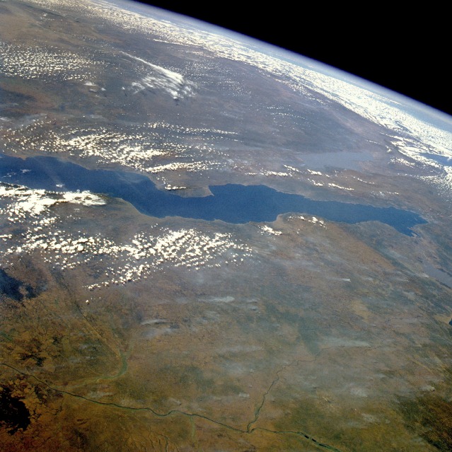 |
| STS51G-034-0012 Lake Tanganyika, Tanzania, Zaire, and Zambia June 1985 This east-looking, high-oblique photograph features Lake Tanganyika--the second deepest freshwater lake in the world with a maximum depth of 4710 feet (1436 meters) and the longest lake in the world, stretching 410 miles (660 kilometers) north to south. Its width varies between 10 and 45 miles (16 and 72 kilometers). The lake, bordered on either side by steep slopes, fills a long narrow trough in the western arm of Africa's Great Rift Valley and supports a thriving fishing industry. The lake basin, a landform in which a block of the Earth's crust dropped down between blocks that rise on either side, began to form nearly 25 million years ago as part of the Great Rift Valley. On the lake's west shore is Tanganyika's sole outlet, the Lukuga River, which is a tributary of the Zaire River (northwest portion of photograph). The Zaire River flows westward and empties into the Atlantic Ocean. Other features in the photograph are shallow, silt-laden Lake Rukwa to the east of the lake and the extreme northern tip of Lake Nyasa near the southeast horizon. |
| Images: | All Available Images Low-Resolution 138k |
|
| Mission: | STS51G |
|
| Roll - Frame: | 34 - 12 |
|
| Geographical Name: | DEM. REP. OF CONGO |
|
| Features: | LAKE TANGANYIKA |
|
| Center Lat x Lon: | 6.6S x 29.5E |
|
| Film Exposure: | U | N=Normal exposure, U=Under exposed, O=Over exposed, F=out of Focus |
| Percentage of Cloud Cover-CLDP: | 40 |
|
| Camera:: | HB |
|
| Camera Tilt: | HO | LO=Low Oblique, HO=High Oblique, NV=Near Vertical |
| Camera Focal Length: | 100 |
|
| Nadir to Photo Center Direction: | E | The direction from the nadir to the center point, N=North, S=South, E=East, W=West |
| Stereo?: | N | Y=Yes there is an adjacent picture of the same area, N=No there isn't |
| Orbit Number: | 16 |
|
| Date: | 19850618 | YYYYMMDD |
| Time: | 105702 | GMT HHMMSS |
| Nadir Lat: | 5.8S |
Latitude of suborbital point of spacecraft |
| Nadir Lon: | 23.8E |
Longitude of suborbital point of spacecraft |
| Sun Azimuth: | 345 | Clockwise angle in degrees from north to the sun measured at the nadir point |
| Space Craft Altitude: | 193 | nautical miles |
| Sun Elevation: | 59 | Angle in degrees between the horizon and the sun, measured at the nadir point |
| Land Views: | VALLEY, UPLAND, PLATEAU |
|
| Water Views: | RIVER, LAKE |
|
| Atmosphere Views: | SMOKE |
|
| Man Made Views: | |
|
| City Views: | |
|
Photo is not associated with any sequences | ||
| NASA Home Page |
JSC Home Page |
JSC Digital Image Collection |
Earth Science & Remote Sensing |
|
This service is provided by the International Space Station program and the JSC Earth Science & Remote Sensing Unit, ARES Division, Exploration Integration Science Directorate.

|