Geographic Region: VENEZUELA
Feature: LAGO DE MARACAIBO
|
Geographic Region: VENEZUELA Feature: LAGO DE MARACAIBO |
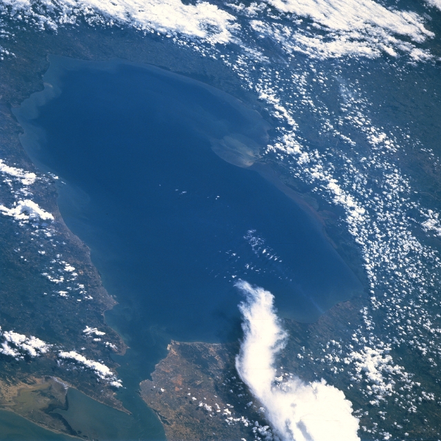 |
| STS51F-46-0077 Lake Maracaibo, Venezuela August 1985 Lake Maracaibo, a semi-enclosed estuary and largest lake in South America, can be seen in this south-southwest-looking view. Lake Maracaibo covers an area of 5100 sq. miles (13,210 sq. km), and extends inland 110 miles (180 km). Tablazo Strait (midway between bottom center and bottom left) connects the lake with the Gulf of Venezuela and Caribbean Sea. The city of Maracaibo is located on the west bank of the 34-mi (55-km)-long strait. The Maracaibo Basin is extremely hot, humid, low, and almost surrounded by mountains (cloud-covered). The northern lake basin is semiarid, but in the south the average annual rainfall is 50 inches (127 cm). Petroleum is the principal industry within the basin. Lake Maracaibo is one of the major oil-producing areas of the world. Just above center of the image a plume of sediment spreads from the delta of the Catatumbo River, the chief supplier of fresh water to the lake. Dredging of the navigation channel through Tablazo Strait has resulted in increased salinity of the lake; eutrophication due to the discharge of sewage and industrial waste has degraded the water quality of the lake, as has pollution from oil exploration and production activities. |
| Images: | All Available Images Low-Resolution 359k |
|
| Mission: | STS51F |
|
| Roll - Frame: | 46 - 77 |
|
| Geographical Name: | VENEZUELA |
|
| Features: | LAGO DE MARACAIBO |
|
| Center Lat x Lon: | 9.5N x 71.5W |
|
| Film Exposure: | N | N=Normal exposure, U=Under exposed, O=Over exposed, F=out of Focus |
| Percentage of Cloud Cover-CLDP: | 60 |
|
| Camera:: | HB |
|
| Camera Tilt: | LO | LO=Low Oblique, HO=High Oblique, NV=Near Vertical |
| Camera Focal Length: | 250 |
|
| Nadir to Photo Center Direction: | S | The direction from the nadir to the center point, N=North, S=South, E=East, W=West |
| Stereo?: | N | Y=Yes there is an adjacent picture of the same area, N=No there isn't |
| Orbit Number: | 78 |
|
| Date: | 19850803 | YYYYMMDD |
| Time: | 172202 | GMT HHMMSS |
| Nadir Lat: | 14.3N |
Latitude of suborbital point of spacecraft |
| Nadir Lon: | 71.1W |
Longitude of suborbital point of spacecraft |
| Sun Azimuth: | 293 | Clockwise angle in degrees from north to the sun measured at the nadir point |
| Space Craft Altitude: | 169 | nautical miles |
| Sun Elevation: | 81 | Angle in degrees between the horizon and the sun, measured at the nadir point |
| Land Views: | BASIN, HILL |
|
| Water Views: | LAKE, STRAIT, GULF |
|
| Atmosphere Views: | |
|
| Man Made Views: | URBAN AREA |
|
| City Views: | |
|
Photo is not associated with any sequences | ||
| NASA Home Page |
JSC Home Page |
JSC Digital Image Collection |
Earth Science & Remote Sensing |
|
This service is provided by the International Space Station program and the JSC Earth Science & Remote Sensing Unit, ARES Division, Exploration Integration Science Directorate.

|