
Geographic Region: KAZAKHSTAN
Feature: TYURATAM, SYR RIVER
|
Geographic Region: KAZAKHSTAN Feature: TYURATAM, SYR RIVER |
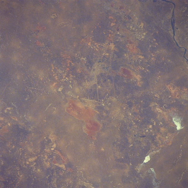 |
| STS51F-44-0018 Baikonur Cosmodrome, Kazakhstan August 1985 The site for the Russian space launches, known as the Baikonur Cosmodrome (also known as Tyuratam), is located in the center of the image. These launch sites, located in the Republic of Kazakhstan are environmentally positioned in a semi-arid region, approximately 125 miles (200 km) from the eastern shore of the Aral Sea. The space center has two separate launch complexes: one for international launches and one for Russian military launches. The Baikonur Cosmodrome launch facilities function in the same way as the Kennedy Space Center along the east coast of Florida; however, the Russian space center covers a much larger area. Prior to the construction of the space center, which started in 1955, at least part of the site was an abandoned open-pit copper mine. The light-colored, linear features near the center of the image shows the interconnected roads and railroads used for the transport of the rockets and personnel throughout the site. Paralleling roads and railroads (light-colored, linear features) are visible along the north side of a short section of the Syr Darya (river--dark features upper right corner). Numerous dry lakebeds (some white in color) are scattered across this relatively flat, dry landscape. |
| Images: | All Available Images Low-Resolution 352k |
|
| Mission: | STS51F |
|
| Roll - Frame: | 44 - 18 |
|
| Geographical Name: | KAZAKHSTAN |
|
| Features: | TYURATAM, SYR RIVER |
|
| Center Lat x Lon: | 46.0N x 63.0E |
|
| Film Exposure: | N | N=Normal exposure, U=Under exposed, O=Over exposed, F=out of Focus |
| Percentage of Cloud Cover-CLDP: | 0 |
|
| Camera:: | HB |
|
| Camera Tilt: | 16 | LO=Low Oblique, HO=High Oblique, NV=Near Vertical |
| Camera Focal Length: | 250 |
|
| Nadir to Photo Center Direction: | SW | The direction from the nadir to the center point, N=North, S=South, E=East, W=West |
| Stereo?: | N | Y=Yes there is an adjacent picture of the same area, N=No there isn't |
| Orbit Number: | 121 |
|
| Date: | 19850806 | YYYYMMDD |
| Time: | 103702 | GMT HHMMSS |
| Nadir Lat: | 46.5N |
Latitude of suborbital point of spacecraft |
| Nadir Lon: | 63.7E |
Longitude of suborbital point of spacecraft |
| Sun Azimuth: | 243 | Clockwise angle in degrees from north to the sun measured at the nadir point |
| Space Craft Altitude: | 176 | nautical miles |
| Sun Elevation: | 44 | Angle in degrees between the horizon and the sun, measured at the nadir point |
| Land Views: | PLAIN |
|
| Water Views: | |
|
| Atmosphere Views: | |
|
| Man Made Views: | |
|
| City Views: | |
|
Photo is not associated with any sequences | ||
| NASA Home Page |
JSC Home Page |
JSC Digital Image Collection |
Earth Science & Remote Sensing |
|
This service is provided by the International Space Station program and the JSC Earth Science & Remote Sensing Unit, ARES Division, Exploration Integration Science Directorate.

|