
Geographic Region: USA-CALIFORNIA
Feature: BAKERSFIELD, OWENS LAKE
|
Geographic Region: USA-CALIFORNIA Feature: BAKERSFIELD, OWENS LAKE |
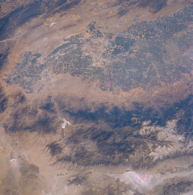 |
| STS51F-042-0034 Sierra Nevada Mountains and San Joaquin Valley, California, U.S.A. August 1985 This photograph encompasses the Sierra Nevada Mountains, reddish Owens Lake, the southern San Joaquin Valley, and the faulted Owens River Valley. Traversing the Sierra Nevada Mountains westward from Owens Lake is the north-south-trending Kern River Valley. This deep valley can be traced from its source near snowcapped Mount Whitney [highest peak in the 48 contiguous states at 14 491 feet (4417 meters)] to Lake Isabella (Y-shaped reservoir with a highly reflective surface) and then southwest to Bakersfield. Immediately west of the forested Sierra Nevada Mountains is the broad expanse of the southern intensively agricultural San Joaquin Valley. Discernible are the vague outline of Bakersfield, several smaller rural cities, and the low mountains and hills to the west and southwest that eventually grade into the Coast Range. |
| Images: | All Available Images Low-Resolution 352k |
|
| Mission: | STS51F |
|
| Roll - Frame: | 42 - 34 |
|
| Geographical Name: | USA-CALIFORNIA |
|
| Features: | BAKERSFIELD, OWENS LAKE |
|
| Center Lat x Lon: | 36.0N x 119W |
|
| Film Exposure: | N | N=Normal exposure, U=Under exposed, O=Over exposed, F=out of Focus |
| Percentage of Cloud Cover-CLDP: | 0 |
|
| Camera:: | HB |
|
| Camera Tilt: | 39 | LO=Low Oblique, HO=High Oblique, NV=Near Vertical |
| Camera Focal Length: | 100 |
|
| Nadir to Photo Center Direction: | W | The direction from the nadir to the center point, N=North, S=South, E=East, W=West |
| Stereo?: | N | Y=Yes there is an adjacent picture of the same area, N=No there isn't |
| Orbit Number: | 81 |
|
| Date: | 19850803 | YYYYMMDD |
| Time: | 220215 | GMT HHMMSS |
| Nadir Lat: | 36.0N |
Latitude of suborbital point of spacecraft |
| Nadir Lon: | 116.7W |
Longitude of suborbital point of spacecraft |
| Sun Azimuth: | 245 | Clockwise angle in degrees from north to the sun measured at the nadir point |
| Space Craft Altitude: | 173 | nautical miles |
| Sun Elevation: | 55 | Angle in degrees between the horizon and the sun, measured at the nadir point |
| Land Views: | MOUNTAIN, RIFT, VALLEY |
|
| Water Views: | LAKE |
|
| Atmosphere Views: | |
|
| Man Made Views: | AGRICULTURE |
|
| City Views: | BAKERSFIELD |
|
Photo is not associated with any sequences | ||
| NASA Home Page |
JSC Home Page |
JSC Digital Image Collection |
Earth Science & Remote Sensing |
|
This service is provided by the International Space Station program and the JSC Earth Science & Remote Sensing Unit, ARES Division, Exploration Integration Science Directorate.

|