
Geographic Region: TURKMENISTAN
Feature: KARA-BOGAZ-GOL BAY
|
Geographic Region: TURKMENISTAN Feature: KARA-BOGAZ-GOL BAY |
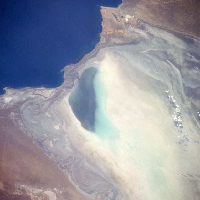 |
| STS51F-040-0064 Kara-Bogaz Gol, Turkmenistan August 1985 This northwest-looking, low-oblique photograph shows the nearly empty basin of Kara-Bogaz Gol, an arm of the Caspian Sea. The average elevation of the deep blue Caspian Sea is 92 feet (28 meters) below sea level. The average elevation of Kara-Bogaz Gol, which acts as a natural evaporation basin--draining water from the Caspian Sea and depositing salts along the shore of the basin--is 102 feet (31 meters) below sea level. In 1979, the government built a dike across the narrow strip of land that separates the sea and the basin. In the 1980s, the low water levels in the Caspian Sea--caused by the diversion of water upstream on the Volga River (the sea's main source of water) for numerous government projects--allowed only a small amount of water into Kara-Bogaz Gol. The climate of this region is semiarid, but lack of precipitation during some years can cause desert-like conditions, resulting in even lower water levels in the sea. This photograph shows that much of the Kara-Bogaz Gol basin is void of water, except near its western end. |
| Images: | All Available Images Low-Resolution 89k |
|
| Mission: | STS51F |
|
| Roll - Frame: | 40 - 64 |
|
| Geographical Name: | TURKMENISTAN |
|
| Features: | KARA-BOGAZ-GOL BAY |
|
| Center Lat x Lon: | 41.0N x 53.0E |
|
| Film Exposure: | N | N=Normal exposure, U=Under exposed, O=Over exposed, F=out of Focus |
| Percentage of Cloud Cover-CLDP: | 5 |
|
| Camera:: | HB |
|
| Camera Tilt: | 46 | LO=Low Oblique, HO=High Oblique, NV=Near Vertical |
| Camera Focal Length: | 250 |
|
| Nadir to Photo Center Direction: | N | The direction from the nadir to the center point, N=North, S=South, E=East, W=West |
| Stereo?: | Y | Y=Yes there is an adjacent picture of the same area, N=No there isn't |
| Orbit Number: | 27 |
|
| Date: | 19850731 | YYYYMMDD |
| Time: | 122224 | GMT HHMMSS |
| Nadir Lat: | 38.2N |
Latitude of suborbital point of spacecraft |
| Nadir Lon: | 54.0E |
Longitude of suborbital point of spacecraft |
| Sun Azimuth: | 265 | Clockwise angle in degrees from north to the sun measured at the nadir point |
| Space Craft Altitude: | 173 | nautical miles |
| Sun Elevation: | 36 | Angle in degrees between the horizon and the sun, measured at the nadir point |
| Land Views: | BASIN, COAST, PLAIN |
|
| Water Views: | SEA, INLET |
|
| Atmosphere Views: | |
|
| Man Made Views: | |
|
| City Views: | |
|
Associated Photos in Sequence:  Photo #: STS51F-40-64 ** Currently displayed photo ** Photo #: STS51F-40-64 ** Currently displayed photo ** Description: TURKMENISTAN, KARA-BOGAZ-GOL--1985; INLET WATER LEVEL INCREASE Sequence ID: 11A  Photo #: STS059-L06-48 Photo #: STS059-L06-48Description: TURKMENISTAN, KARA-BOGAZ-GOL--1994; INLET WATER LEVEL INCREASE Sequence ID: 11B  Photo #: STS073-701-33 Photo #: STS073-701-33Description: TURKMENISTAN, KARA-BOGAZ-GOL--1995; INLET WATER LEVEL INCREASE Sequence ID: 11C | ||
| NASA Home Page |
JSC Home Page |
JSC Digital Image Collection |
Earth Science & Remote Sensing |
|
This service is provided by the International Space Station program and the JSC Earth Science & Remote Sensing Unit, ARES Division, Exploration Integration Science Directorate.

|