
Geographic Region: USA-CALIFORNIA
Feature: IMPERIAL VALLEY
|
Geographic Region: USA-CALIFORNIA Feature: IMPERIAL VALLEY |
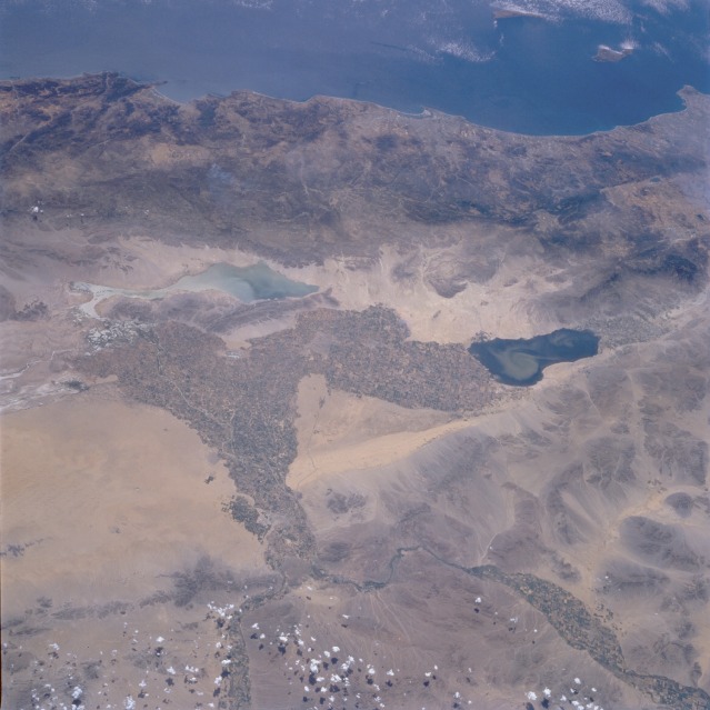 |
| STS51F-038-0045 Southern California, U.S.A., and Northwestern Mexico August 1985 The irrigated agricultural field patterns stand out in marked contrast to the naturally nonvegetated desert region of the southwestern United States and northwestern Mexico. This view provides a rather rare opportunity to observe a manmade boundary between the two countries. (Look for the abrupt changes in agricultural field sizes and the regular field orientation that creates an east-west line along the southern edge of the California Imperial Valley.) Two rivers, the Colorado and the Gila, are the major sources of water for this arid region. The Colorado River enters this photograph from the northeast, and the Gila River enters from the east; both rivers flow generally south-southwest. Two sizable lakes (the Salton Sea in southern California and Laguna Salada in Mexico) are observed. A swirling sediment plume, probably created by surface winds, is seen in the Salton Sea. A well-defined area of distinctive sand dunes, called the Sand Hills, is located just to the east of the field patterns in the Imperial Valley. Several fragmented mountain ranges trend in a southeast-northwest direction along the southern California and northern Baja California coasts. |
| Images: | All Available Images Low-Resolution 99k |
|
| Mission: | STS51F |
|
| Roll - Frame: | 38 - 45 |
|
| Geographical Name: | USA-CALIFORNIA |
|
| Features: | IMPERIAL VALLEY |
|
| Center Lat x Lon: | 33.0N x 115.5W |
|
| Film Exposure: | N | N=Normal exposure, U=Under exposed, O=Over exposed, F=out of Focus |
| Percentage of Cloud Cover-CLDP: | 20 |
|
| Camera:: | HB |
|
| Camera Tilt: | 50 | LO=Low Oblique, HO=High Oblique, NV=Near Vertical |
| Camera Focal Length: | 100 |
|
| Nadir to Photo Center Direction: | W | The direction from the nadir to the center point, N=North, S=South, E=East, W=West |
| Stereo?: | N | Y=Yes there is an adjacent picture of the same area, N=No there isn't |
| Orbit Number: | 65 |
|
| Date: | 19850802 | YYYYMMDD |
| Time: | 214857 | GMT HHMMSS |
| Nadir Lat: | 32.7N |
Latitude of suborbital point of spacecraft |
| Nadir Lon: | 112.1W |
Longitude of suborbital point of spacecraft |
| Sun Azimuth: | 251 | Clockwise angle in degrees from north to the sun measured at the nadir point |
| Space Craft Altitude: | 173 | nautical miles |
| Sun Elevation: | 56 | Angle in degrees between the horizon and the sun, measured at the nadir point |
| Land Views: | MOUNTAIN, DESERT, COAST |
|
| Water Views: | LAKE, RIVER, DELTA |
|
| Atmosphere Views: | |
|
| Man Made Views: | AGRICULTURE |
|
| City Views: | |
|
Photo is not associated with any sequences | ||
| NASA Home Page |
JSC Home Page |
JSC Digital Image Collection |
Earth Science & Remote Sensing |
|
This service is provided by the International Space Station program and the JSC Earth Science & Remote Sensing Unit, ARES Division, Exploration Integration Science Directorate.

|