
Geographic Region: USA-WASHINGTON
Feature: MOSES LAKE
|
Geographic Region: USA-WASHINGTON Feature: MOSES LAKE |
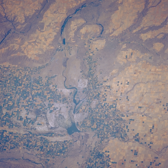 |
| STS51F-035-0012 Moses Lake Area, Washington, U.S.A. August 1985 Moses Lake and Potholes Reservoir are featured in this low-oblique, north-looking photograph. Snakelike Moses Lake [16 miles (25 kilometers) long] extends northward from the small farming community of Moses Lake, visible near the center of the photograph. Potholes Reservoir (south of Moses Lake) has a low water level in this summer view; Soap Lake and larger Lake Lenore are apparent near the top center. Stretching to the west, east, and south of Moses Lake are numerous pivot-irrigation fields. Interstate Highway 90, which traverses west-east just south of the community of Moses Lake, is barely discernible. |
| Images: | All Available Images Low-Resolution 343k |
|
| Mission: | STS51F |
|
| Roll - Frame: | 35 - 12 |
|
| Geographical Name: | USA-WASHINGTON |
|
| Features: | MOSES LAKE |
|
| Center Lat x Lon: | 47.0N x 119.5W |
|
| Film Exposure: | N | N=Normal exposure, U=Under exposed, O=Over exposed, F=out of Focus |
| Percentage of Cloud Cover-CLDP: | 0 |
|
| Camera:: | HB |
|
| Camera Tilt: | 35 | LO=Low Oblique, HO=High Oblique, NV=Near Vertical |
| Camera Focal Length: | 250 |
|
| Nadir to Photo Center Direction: | NW | The direction from the nadir to the center point, N=North, S=South, E=East, W=West |
| Stereo?: | N | Y=Yes there is an adjacent picture of the same area, N=No there isn't |
| Orbit Number: | 82 |
|
| Date: | 19850803 | YYYYMMDD |
| Time: | 233802 | GMT HHMMSS |
| Nadir Lat: | 46.0N |
Latitude of suborbital point of spacecraft |
| Nadir Lon: | 117.7W |
Longitude of suborbital point of spacecraft |
| Sun Azimuth: | 256 | Clockwise angle in degrees from north to the sun measured at the nadir point |
| Space Craft Altitude: | 176 | nautical miles |
| Sun Elevation: | 36 | Angle in degrees between the horizon and the sun, measured at the nadir point |
| Land Views: | |
|
| Water Views: | LAKE |
|
| Atmosphere Views: | |
|
| Man Made Views: | AGRICULTURE |
|
| City Views: | |
|
Photo is not associated with any sequences | ||
| NASA Home Page |
JSC Home Page |
JSC Digital Image Collection |
Earth Science & Remote Sensing |
|
This service is provided by the International Space Station program and the JSC Earth Science & Remote Sensing Unit, ARES Division, Exploration Integration Science Directorate.

|