
Geographic Region: BANGLADESH
Feature: MONSOON
|
Geographic Region: BANGLADESH Feature: MONSOON |
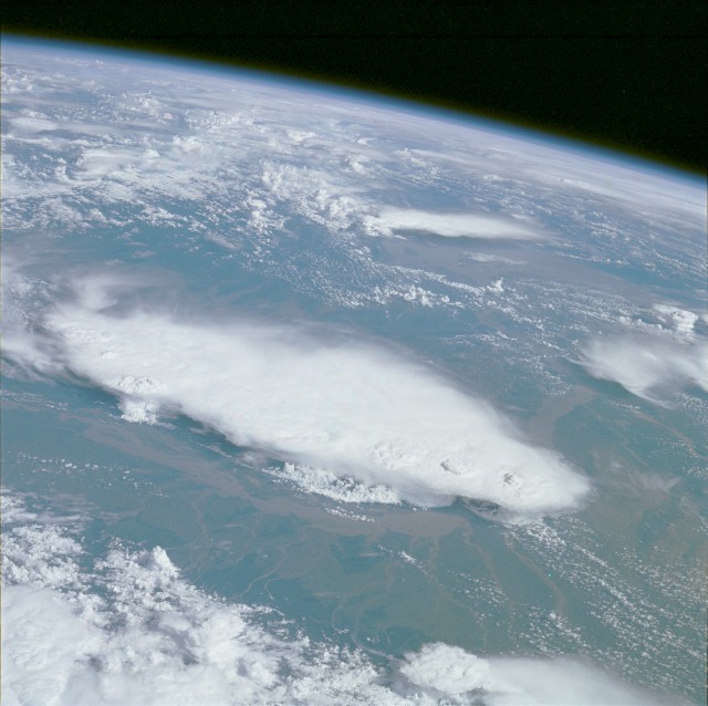 |
| STS51F-31-69 Monsoonal Thunderstorms, Bangladesh and India July 1985 This magnificent, high-oblique photograph was taken from above the eastern Himalaya Mountains looking southeast across the floodplain of the Brahmaputra River and the cloud-covered Khasi Hills into the Bay of Bengal. A well-developed cluster of mature monsoonal thunderstorms over the Khasi Hills (center of photograph) can be seen. A variety of meteorological phenomena are visible, such as overshooting thunderstorm tops, towers, squall lines, and areas of probable high-speed downdrafts or microbursts. Just to the north of the cloud-covered Khasi Hills, the Brahmaputra River can be seen in flood stage. During some years of exceedingly heavy monsoonal rainfall, the width of the river in flood can expand to over 50 miles (80 kilometers) in certain locations. Within the Khasi Hills region are locations where annual rainfall totals are among the highest in the world, exceeding 500 inches (1300 centimeters) per year. In appreciating the great amount of rainfall per year, it is further useful to realize that almost all of the rainfall occurs between late May and mid-September. |
| Images: | All Available Images Low-Resolution 100k |
|
| Mission: | STS51F |
|
| Roll - Frame: | 31 - 69 |
|
| Geographical Name: | BANGLADESH |
|
| Features: | MONSOON |
|
| Center Lat x Lon: | 25.0N x 90.5E |
|
| Film Exposure: | N | N=Normal exposure, U=Under exposed, O=Over exposed, F=out of Focus |
| Percentage of Cloud Cover-CLDP: | 70 |
|
| Camera:: | HB |
|
| Camera Tilt: | HO | LO=Low Oblique, HO=High Oblique, NV=Near Vertical |
| Camera Focal Length: | 100 |
|
| Nadir to Photo Center Direction: | S | The direction from the nadir to the center point, N=North, S=South, E=East, W=West |
| Stereo?: | N | Y=Yes there is an adjacent picture of the same area, N=No there isn't |
| Orbit Number: | 25 |
|
| Date: | 19850731 | YYYYMMDD |
| Time: | 091732 | GMT HHMMSS |
| Nadir Lat: | 30.1N |
Latitude of suborbital point of spacecraft |
| Nadir Lon: | 88.5E |
Longitude of suborbital point of spacecraft |
| Sun Azimuth: | 265 | Clockwise angle in degrees from north to the sun measured at the nadir point |
| Space Craft Altitude: | 172 | nautical miles |
| Sun Elevation: | 46 | Angle in degrees between the horizon and the sun, measured at the nadir point |
| Land Views: | BASIN, FOREST, PLAIN, HILL |
|
| Water Views: | RIVER |
|
| Atmosphere Views: | THUNDERSTORM |
|
| Man Made Views: | |
|
| City Views: | |
|
Photo is not associated with any sequences | ||
| NASA Home Page |
JSC Home Page |
JSC Digital Image Collection |
Earth Science & Remote Sensing |
|
This service is provided by the International Space Station program and the JSC Earth Science & Remote Sensing Unit, ARES Division, Exploration Integration Science Directorate.

|