
Geographic Region: GUATEMALA
Feature: QUEZALTENANGO
|
Geographic Region: GUATEMALA Feature: QUEZALTENANGO |
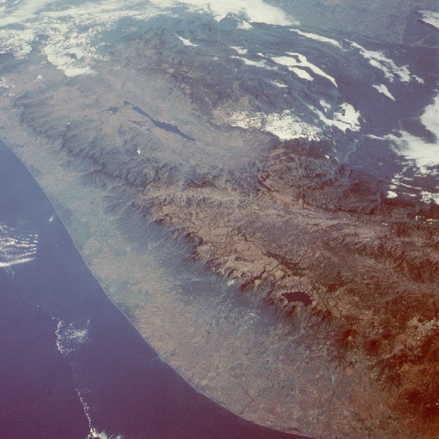 |
| STS51C-038-0031 Sierra Madre, Guatemala January 1985 This low-oblique photograph produces an almost 3-dimensional quality for viewing the Pacific coast of southern Mexico and western Guatemala. The narrow coastal plain lies in marked contrast to the rugged Sierra Madre and Sierra de los Cuchumatanes of western Guatemala. A pronounced chain of volcanoes parallels the Pacific coast along the western edge of the mountainous terrain. Two neighboring volcanoes, Agua and Fuego, are visible near the southeastern edge of the photograph. More easterly Agua Volcano exceeds 12 330 feet (3760 meters) and erupted in 1541, almost completely burying the village of Cuidad Vieja. During recent years, Fuego Volcano [summit of 12 310 feet (3752 meters)] has emitted smoke and steam but has not caused great destruction. The outline of the capital, Guatemala City, is barely discernible just east of these two volcanoes. Deep blue Lake Atitlán, 35 miles (57 kilometers) west of Guatemala City, has a surface elevation of 5125 feet (1560 meters) above sea level, and further northwest, elongated Angostura Reservoir is visible in southern Mexico. A major unidentified east-west fault line extends across northwest Guatemala through a small part of southern Mexico. |
| Images: | All Available Images Low-Resolution 133k |
|
| Mission: | STS51C |
|
| Roll - Frame: | 38 - 31 |
|
| Geographical Name: | GUATEMALA |
|
| Features: | QUEZALTENANGO |
|
| Center Lat x Lon: | 15.0N x 91.5W |
|
| Film Exposure: | N | N=Normal exposure, U=Under exposed, O=Over exposed, F=out of Focus |
| Percentage of Cloud Cover-CLDP: | 30 |
|
| Camera:: | HB |
|
| Camera Tilt: | 43 | LO=Low Oblique, HO=High Oblique, NV=Near Vertical |
| Camera Focal Length: | 100 |
|
| Nadir to Photo Center Direction: | N | The direction from the nadir to the center point, N=North, S=South, E=East, W=West |
| Stereo?: | Y | Y=Yes there is an adjacent picture of the same area, N=No there isn't |
| Orbit Number: | 45 |
|
| Date: | 19850127 | YYYYMMDD |
| Time: | 143936 | GMT HHMMSS |
| Nadir Lat: | 12.0N |
Latitude of suborbital point of spacecraft |
| Nadir Lon: | 90.5W |
Longitude of suborbital point of spacecraft |
| Sun Azimuth: | 119 | Clockwise angle in degrees from north to the sun measured at the nadir point |
| Space Craft Altitude: | 202 | nautical miles |
| Sun Elevation: | 28 | Angle in degrees between the horizon and the sun, measured at the nadir point |
| Land Views: | MOUNTAIN, PLATEAU, COAST, FAULT, PLAIN |
|
| Water Views: | RESERVOIR, OCEAN, RIVER |
|
| Atmosphere Views: | SMOKE |
|
| Man Made Views: | DAM, AGRICULTURE |
|
| City Views: | |
|
Photo is not associated with any sequences | ||
| NASA Home Page |
JSC Home Page |
JSC Digital Image Collection |
Earth Science & Remote Sensing |
|
This service is provided by the International Space Station program and the JSC Earth Science & Remote Sensing Unit, ARES Division, Exploration Integration Science Directorate.

|