
Geographic Region: USA-GEORGIA
Feature: OKEFENOKEE SWAMP, SMOKE
|
Geographic Region: USA-GEORGIA Feature: OKEFENOKEE SWAMP, SMOKE |
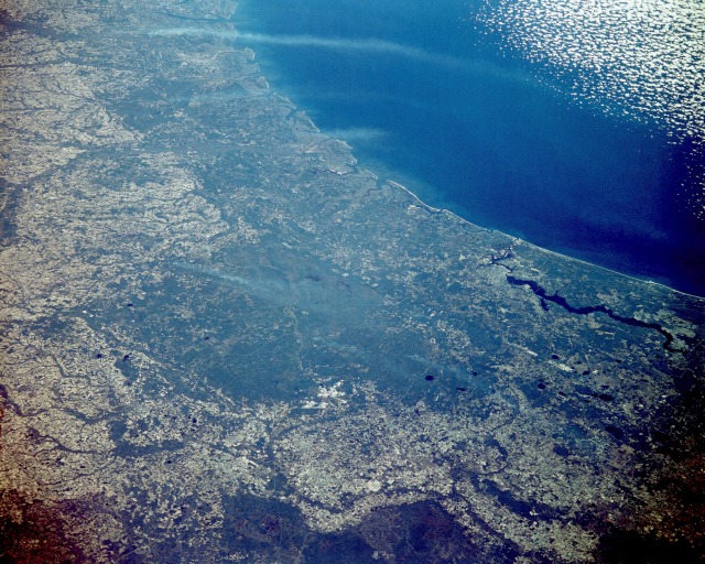 |
| STS51C-143-0029 The Okefenokee Swamp Region, Georgia and Florida, U.S.A. January 1985 This northeast-looking, low-oblique photograph shows the Okefenokee Swamp (dark greenish-blue area near the center of the photograph) and the Atlantic Coastal Plain of southeastern Georgia and northern Florida. The Okefenokee Swamp is considered a deciduous forest, or bottom hardwood swamp, in a coastal basin that is flooded annually by slow-moving streams. The Suwannee River rises and is the main river or stream in the swamp. The Okefenokee Swamp is 40 miles (64 kilometers) long, averages 20 miles (32 kilometers) in width, and covers 600 square miles (1555 square kilometers). The swamp sits in a saucer-shaped depression with low ridges and small islands rising above the water and vegetation cover. Tall bald cypress trees, relatives of the California redwoods, provide a rich habitat for numerous species of wildlife and a host of epiphytic and climbing plants. This type of cypress swamp depends for its survival on periodic fires, as well as water. White smoke plumes are scattered throughout the swamp area. Jacksonville, Florida, at the north end of the Saint Johns River, can be seen to the east-southeast of the Okefenokee Swamp area. The barrier islands along the southeastern Georgia coast are visible to the east and northeast of the swamp region. |
| Images: | All Available Images Low-Resolution 156k |
|
| Mission: | STS51C |
|
| Roll - Frame: | 143 - 29 |
|
| Geographical Name: | USA-GEORGIA |
|
| Features: | OKEFENOKEE SWAMP, SMOKE |
|
| Center Lat x Lon: | 31.0N x 82W |
|
| Film Exposure: | N | N=Normal exposure, U=Under exposed, O=Over exposed, F=out of Focus |
| Percentage of Cloud Cover-CLDP: | 5 |
|
| Camera:: | LH |
|
| Camera Tilt: | LO=Low Oblique, HO=High Oblique, NV=Near Vertical |
|
| Camera Focal Length: | 250 |
|
| Nadir to Photo Center Direction: | The direction from the nadir to the center point, N=North, S=South, E=East, W=West |
|
| Stereo?: | N | Y=Yes there is an adjacent picture of the same area, N=No there isn't |
| Orbit Number: | |
|
| Date: | 198501__ | YYYYMMDD |
| Time: | GMT HHMMSS |
|
| Nadir Lat: | N |
Latitude of suborbital point of spacecraft |
| Nadir Lon: | E |
Longitude of suborbital point of spacecraft |
| Sun Azimuth: | Clockwise angle in degrees from north to the sun measured at the nadir point |
|
| Space Craft Altitude: | nautical miles |
|
| Sun Elevation: | Angle in degrees between the horizon and the sun, measured at the nadir point |
|
| Land Views: | PLAIN, FOREST |
|
| Water Views: | RIVER, SWAMP |
|
| Atmosphere Views: | SMOKE |
|
| Man Made Views: | AGRICULTURE |
|
| City Views: | |
|
Photo is not associated with any sequences | ||
| NASA Home Page |
JSC Home Page |
JSC Digital Image Collection |
Earth Science & Remote Sensing |
|
This service is provided by the International Space Station program and the JSC Earth Science & Remote Sensing Unit, ARES Division, Exploration Integration Science Directorate.

|