
Geographic Region: USA-LOUISIANA
Feature: MISSISSIPPI DELTA
|
Geographic Region: USA-LOUISIANA Feature: MISSISSIPPI DELTA |
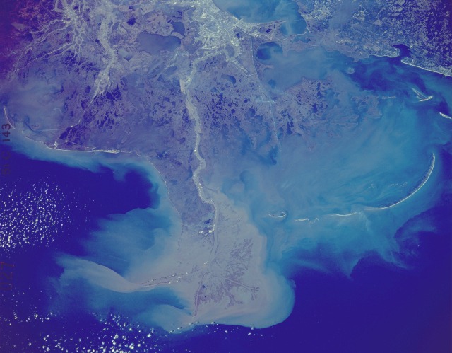 |
| STS51C-143-0027 Mississippi River Delta and Coastal Louisiana, U.S.A. January 1985 This synoptic photograph of the north-central Gulf of Mexico shows southeastern Louisiana and the southwest coast of Mississippi. The three major features in this photograph are the Mississippi River, its delta, and the city of New Orleans located along the south side of Lake Pontchartrain (barely visible at the northern edge of the photograph). This photograph shows the effects of dynamic events, such as wind direction (note the smoke plumes southeast of New Orleans) and the sediment pattern caused by near-shore water currents around the mouth of the Mississippi River--the world's only "bird's foot" delta. The elongated, narrow strips of land parallel to the coastline are fragmented barrier islands--most notably the Chandeleur Islands. Close observation of the field patterns along the Mississippi River in Louisiana shows definite French influence. These rectangular farms, called "long lots," are laid out in sequence, perpendicular to the river, allowing each farm access to the waterways. Swamplands can be seen south of New Orleans. |
| Images: | All Available Images Low-Resolution 87k |
|
| Mission: | STS51C |
|
| Roll - Frame: | 143 - 27 |
|
| Geographical Name: | USA-LOUISIANA |
|
| Features: | MISSISSIPPI DELTA |
|
| Center Lat x Lon: | 29.5N x 89.5W |
|
| Film Exposure: | N | N=Normal exposure, U=Under exposed, O=Over exposed, F=out of Focus |
| Percentage of Cloud Cover-CLDP: | 5 |
|
| Camera:: | LH |
|
| Camera Tilt: | NV | LO=Low Oblique, HO=High Oblique, NV=Near Vertical |
| Camera Focal Length: | 250 |
|
| Nadir to Photo Center Direction: | The direction from the nadir to the center point, N=North, S=South, E=East, W=West |
|
| Stereo?: | Y | Y=Yes there is an adjacent picture of the same area, N=No there isn't |
| Orbit Number: | |
|
| Date: | 198501__ | YYYYMMDD |
| Time: | GMT HHMMSS |
|
| Nadir Lat: | N |
Latitude of suborbital point of spacecraft |
| Nadir Lon: | E |
Longitude of suborbital point of spacecraft |
| Sun Azimuth: | Clockwise angle in degrees from north to the sun measured at the nadir point |
|
| Space Craft Altitude: | nautical miles |
|
| Sun Elevation: | Angle in degrees between the horizon and the sun, measured at the nadir point |
|
| Land Views: | ISLAND, COAST, PLAIN |
|
| Water Views: | RIVER, DELTA, GULF, CHANNEL, SEDIMENT, SWAMP, LAKE |
|
| Atmosphere Views: | SMOKE, PLUME |
|
| Man Made Views: | AGRICULTURE, URBAN AREA |
|
| City Views: | |
|
Photo is not associated with any sequences | ||
| NASA Home Page |
JSC Home Page |
JSC Digital Image Collection |
Earth Science & Remote Sensing |
|
This service is provided by the International Space Station program and the JSC Earth Science & Remote Sensing Unit, ARES Division, Exploration Integration Science Directorate.

|