
Geographic Region: USA-LOUISIANA
Feature: NEW ORLEANS
|
Geographic Region: USA-LOUISIANA Feature: NEW ORLEANS |
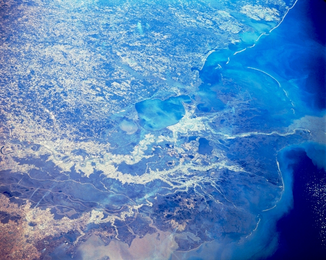 |
| STS51C-143-17 Southern Louisiana, U.S.A. January 1985 This panoramic, northeast-looking photographs encompasses an area from the sediment-laden Atchafalaya Bay (bottom of photograph) to just beyond Mobile Bay, Alabama, (upper right corner). Urban New Orleans lies along the south shore of roughly oval Lake Pontchartrain. The main channel of the Mississippi River is discernible from just north of Baton Rouge to the northern half of the "bird's foot" delta at the mouth of the river. Immediately west of the Mississippi River is its major distributary, the Atchafalaya River. The mottled terrain is a mixture of darker, forested lands and lighter, nonforested areas. The barrier islands off the coasts of Alabama, Mississippi, and southeastern Louisiana create a partial obstacle between Mississippi Sound and the open waters of the Gulf of Mexico. |
| Images: | All Available Images Low-Resolution 337k |
|
| Mission: | STS51C |
|
| Roll - Frame: | 143 - 17 |
|
| Geographical Name: | USA-LOUISIANA |
|
| Features: | NEW ORLEANS |
|
| Center Lat x Lon: | 30.0N x 90.5W |
|
| Film Exposure: | N | N=Normal exposure, U=Under exposed, O=Over exposed, F=out of Focus |
| Percentage of Cloud Cover-CLDP: | 0 |
|
| Camera:: | LH |
|
| Camera Tilt: | LO | LO=Low Oblique, HO=High Oblique, NV=Near Vertical |
| Camera Focal Length: | 250 |
|
| Nadir to Photo Center Direction: | The direction from the nadir to the center point, N=North, S=South, E=East, W=West |
|
| Stereo?: | N | Y=Yes there is an adjacent picture of the same area, N=No there isn't |
| Orbit Number: | |
|
| Date: | 198501__ | YYYYMMDD |
| Time: | GMT HHMMSS |
|
| Nadir Lat: | N |
Latitude of suborbital point of spacecraft |
| Nadir Lon: | E |
Longitude of suborbital point of spacecraft |
| Sun Azimuth: | Clockwise angle in degrees from north to the sun measured at the nadir point |
|
| Space Craft Altitude: | nautical miles |
|
| Sun Elevation: | Angle in degrees between the horizon and the sun, measured at the nadir point |
|
| Land Views: | PLAIN, ISLAND |
|
| Water Views: | RIVER, SWAMP, BAY, LAKE, SEDIMENT |
|
| Atmosphere Views: | |
|
| Man Made Views: | URBAN AREA |
|
| City Views: | |
|
Photo is not associated with any sequences | ||
| NASA Home Page |
JSC Home Page |
JSC Digital Image Collection |
Earth Science & Remote Sensing |
|
This service is provided by the International Space Station program and the JSC Earth Science & Remote Sensing Unit, ARES Division, Exploration Integration Science Directorate.

|