
Geographic Region: USA-GEORGIA
Feature: DALTON, CHATTANOOGA
|
Geographic Region: USA-GEORGIA Feature: DALTON, CHATTANOOGA |
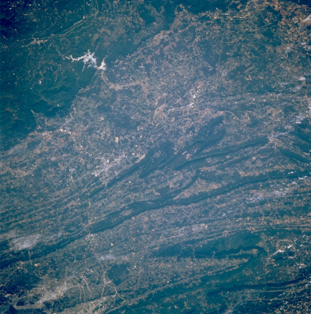 |
| STS51B-53-0019 Dalton Area, Georgia, U.S.A. May 1985 Apparent in this southeast-looking photograph is sunglint on light, irregular-shaped Carters Lake within the heavily forested Chattahochee National Forest of northwest Georgia. Also visible are numerous dark, forested, paralleling ridgelines and intervening valleys oriented in a northeast-southwest direction. Discernible are highly reflective Dalton and Calhoun (near center of the photograph) and extending southeast from Chattanooga, Tennessee, narrow, linear highways (bottom left side), including Interstate Highway 75. |
| Images: | All Available Images Low-Resolution 391k |
|
| Mission: | STS51B |
|
| Roll - Frame: | 53 - 19 |
|
| Geographical Name: | USA-GEORGIA |
|
| Features: | DALTON, CHATTANOOGA |
|
| Center Lat x Lon: | 34.5N x 85W |
|
| Film Exposure: | N | N=Normal exposure, U=Under exposed, O=Over exposed, F=out of Focus |
| Percentage of Cloud Cover-CLDP: | 10 |
|
| Camera:: | HB |
|
| Camera Tilt: | NV | LO=Low Oblique, HO=High Oblique, NV=Near Vertical |
| Camera Focal Length: | 250 |
|
| Nadir to Photo Center Direction: | The direction from the nadir to the center point, N=North, S=South, E=East, W=West |
|
| Stereo?: | Y | Y=Yes there is an adjacent picture of the same area, N=No there isn't |
| Orbit Number: | 79 |
|
| Date: | 1985____ | YYYYMMDD |
| Time: | GMT HHMMSS |
|
| Nadir Lat: | N |
Latitude of suborbital point of spacecraft |
| Nadir Lon: | E |
Longitude of suborbital point of spacecraft |
| Sun Azimuth: | Clockwise angle in degrees from north to the sun measured at the nadir point |
|
| Space Craft Altitude: | nautical miles |
|
| Sun Elevation: | Angle in degrees between the horizon and the sun, measured at the nadir point |
|
| Land Views: | FOREST, VALLEY, MOUNTAIN |
|
| Water Views: | LAKE |
|
| Atmosphere Views: | |
|
| Man Made Views: | |
|
| City Views: | |
|
Photo is not associated with any sequences | ||
| NASA Home Page |
JSC Home Page |
JSC Digital Image Collection |
Earth Science & Remote Sensing |
|
This service is provided by the International Space Station program and the JSC Earth Science & Remote Sensing Unit, ARES Division, Exploration Integration Science Directorate.

|