Geographic Region: JAPAN
Feature: SHIKOKU
|
Geographic Region: JAPAN Feature: SHIKOKU |
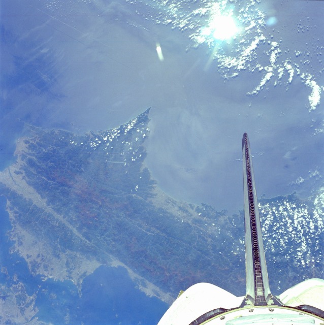 |
| STS51B-44-0052 Skikoku Island, Japan May 1985 The smallest of the four main islands of Japan, most of eastern half of Skikoku Island can be seen in this south-southeast-looking low-oblique view. Skikoku is separated from the islands of Honshu and Kyushv by the Inland Sea (bottom left). The interior of the island is mountainous and heavily forested, and is drained by many rivers, including the Yoshimo, which sits in a large rift or fault valley (bottom center to center left). Flat regions along the coasts and in the river valleys are densely settled with agriculture or urban developments. |
| Images: | All Available Images Low-Resolution 107k |
|
| Mission: | STS51B |
|
| Roll - Frame: | 44 - 52 |
|
| Geographical Name: | JAPAN |
|
| Features: | SHIKOKU |
|
| Center Lat x Lon: | 33.5N x 134.0E |
|
| Film Exposure: | N | N=Normal exposure, U=Under exposed, O=Over exposed, F=out of Focus |
| Percentage of Cloud Cover-CLDP: | 30 |
|
| Camera:: | HB |
|
| Camera Tilt: | NV | LO=Low Oblique, HO=High Oblique, NV=Near Vertical |
| Camera Focal Length: | 100 |
|
| Nadir to Photo Center Direction: | The direction from the nadir to the center point, N=North, S=South, E=East, W=West |
|
| Stereo?: | Y | Y=Yes there is an adjacent picture of the same area, N=No there isn't |
| Orbit Number: | 23 |
|
| Date: | 1985____ | YYYYMMDD |
| Time: | GMT HHMMSS |
|
| Nadir Lat: | N |
Latitude of suborbital point of spacecraft |
| Nadir Lon: | E |
Longitude of suborbital point of spacecraft |
| Sun Azimuth: | Clockwise angle in degrees from north to the sun measured at the nadir point |
|
| Space Craft Altitude: | nautical miles |
|
| Sun Elevation: | Angle in degrees between the horizon and the sun, measured at the nadir point |
|
| Land Views: | ISLAND, FAULT, MOUNTAIN |
|
| Water Views: | SEA, STRAIT, RIVER |
|
| Atmosphere Views: | |
|
| Man Made Views: | |
|
| City Views: | |
|
Photo is not associated with any sequences | ||
| NASA Home Page |
JSC Home Page |
JSC Digital Image Collection |
Earth Science & Remote Sensing |
|
This service is provided by the International Space Station program and the JSC Earth Science & Remote Sensing Unit, ARES Division, Exploration Integration Science Directorate.

|