
Geographic Region: USA-MINNESOTA
Feature: OTTER TAIL LAKE
|
Geographic Region: USA-MINNESOTA Feature: OTTER TAIL LAKE |
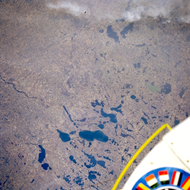 |
| STS51B-038-0052 Otter Tail Lake, Minnesota, U.S.A. May 1985 Otter Tail Lake [12 miles (19 kilometers) long] is the largest of the lakes featured in this southeast-looking, low-oblique photograph of west-central Minnesota. These lakes were formed more than 10 000 years ago as glaciers from the last ice age retreated northward. Visible are light green Christina Lake (right center of the photograph) and Miltona Lake and Ida Lake (near top center), north of Alexandria (not discernible). Excellent fishing in area lakes brings visitors from all over the United States to this region. |
| Images: | All Available Images Low-Resolution 362k |
|
| Mission: | STS51B |
|
| Roll - Frame: | 38 - 52 |
|
| Geographical Name: | USA-MINNESOTA |
|
| Features: | OTTER TAIL LAKE |
|
| Center Lat x Lon: | 46.5N x 95.5W |
|
| Film Exposure: | N | N=Normal exposure, U=Under exposed, O=Over exposed, F=out of Focus |
| Percentage of Cloud Cover-CLDP: | 10 |
|
| Camera:: | HB |
|
| Camera Tilt: | NV | LO=Low Oblique, HO=High Oblique, NV=Near Vertical |
| Camera Focal Length: | 250 |
|
| Nadir to Photo Center Direction: | The direction from the nadir to the center point, N=North, S=South, E=East, W=West |
|
| Stereo?: | N | Y=Yes there is an adjacent picture of the same area, N=No there isn't |
| Orbit Number: | 18 |
|
| Date: | 1985____ | YYYYMMDD |
| Time: | GMT HHMMSS |
|
| Nadir Lat: | N |
Latitude of suborbital point of spacecraft |
| Nadir Lon: | E |
Longitude of suborbital point of spacecraft |
| Sun Azimuth: | Clockwise angle in degrees from north to the sun measured at the nadir point |
|
| Space Craft Altitude: | nautical miles |
|
| Sun Elevation: | Angle in degrees between the horizon and the sun, measured at the nadir point |
|
| Land Views: | PLAIN |
|
| Water Views: | LAKE |
|
| Atmosphere Views: | |
|
| Man Made Views: | |
|
| City Views: | |
|
Photo is not associated with any sequences | ||
| NASA Home Page |
JSC Home Page |
JSC Digital Image Collection |
Earth Science & Remote Sensing |
|
This service is provided by the International Space Station program and the JSC Earth Science & Remote Sensing Unit, ARES Division, Exploration Integration Science Directorate.

|