
Geographic Region: USA-MONTANA
Feature: FLATHEAD LAKE
|
Geographic Region: USA-MONTANA Feature: FLATHEAD LAKE |
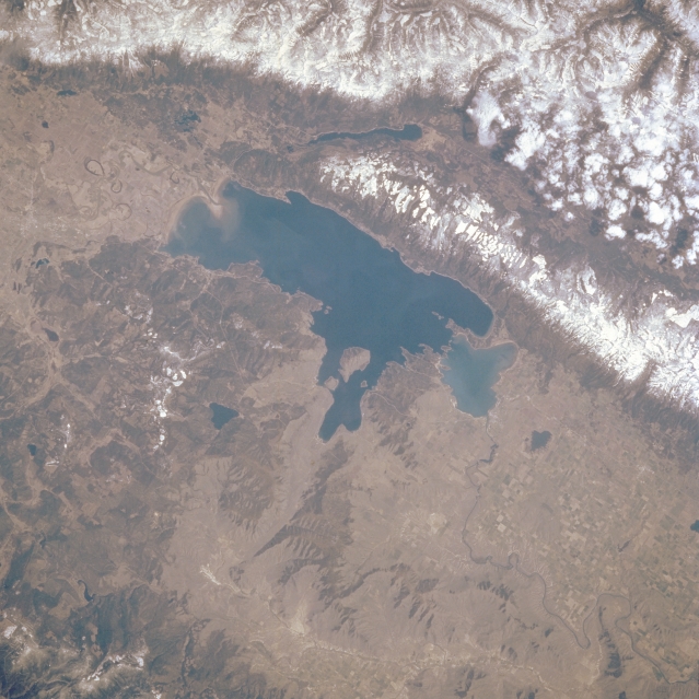 |
| STS51B-038-0102 Flathead Lake, Montana, U.S.A. May 1985 The irregular shoreline of Flathead Lake is discernible in this northeast-looking, low-oblique photograph. The lake [30 miles (48 kilometers) long and 12 to 14 miles (19 to 23 kilometers) wide], located in a depression that remained after a large block of ice retreated during the last ice age, is used for recreation and some irrigation. Kalispell is barely discernible north of the lake. East of the lake are the snow-covered, rugged peaks of the Mission Range, east of which is elongated, glacier-carved Swan Valley. Clouds overhang the peaks of the Swan Range, which is east of Swan Valley. To the east-northeast of Flathead Lake is Swan Lake, and to the west are the lower, less rugged Salish Mountains. Agricultural field patterns appear south of the lake in Flathead Valley. |
| Images: | All Available Images Low-Resolution 325k |
|
| Mission: | STS51B |
|
| Roll - Frame: | 38 - 102 |
|
| Geographical Name: | USA-MONTANA |
|
| Features: | FLATHEAD LAKE |
|
| Center Lat x Lon: | 48.0N x 114W |
|
| Film Exposure: | N | N=Normal exposure, U=Under exposed, O=Over exposed, F=out of Focus |
| Percentage of Cloud Cover-CLDP: | 20 |
|
| Camera:: | HB |
|
| Camera Tilt: | NV | LO=Low Oblique, HO=High Oblique, NV=Near Vertical |
| Camera Focal Length: | 250 |
|
| Nadir to Photo Center Direction: | The direction from the nadir to the center point, N=North, S=South, E=East, W=West |
|
| Stereo?: | Y | Y=Yes there is an adjacent picture of the same area, N=No there isn't |
| Orbit Number: | 19 |
|
| Date: | 1985____ | YYYYMMDD |
| Time: | GMT HHMMSS |
|
| Nadir Lat: | N |
Latitude of suborbital point of spacecraft |
| Nadir Lon: | E |
Longitude of suborbital point of spacecraft |
| Sun Azimuth: | Clockwise angle in degrees from north to the sun measured at the nadir point |
|
| Space Craft Altitude: | nautical miles |
|
| Sun Elevation: | Angle in degrees between the horizon and the sun, measured at the nadir point |
|
| Land Views: | MOUNTAIN, FAULT |
|
| Water Views: | LAKE |
|
| Atmosphere Views: | |
|
| Man Made Views: | AGRICULTURE |
|
| City Views: | |
|
Photo is not associated with any sequences | ||
| NASA Home Page |
JSC Home Page |
JSC Digital Image Collection |
Earth Science & Remote Sensing |
|
This service is provided by the International Space Station program and the JSC Earth Science & Remote Sensing Unit, ARES Division, Exploration Integration Science Directorate.

|