
Geographic Region: MEXICO
Feature: POPOCATEPETL, PUEBLA
|
Geographic Region: MEXICO Feature: POPOCATEPETL, PUEBLA |
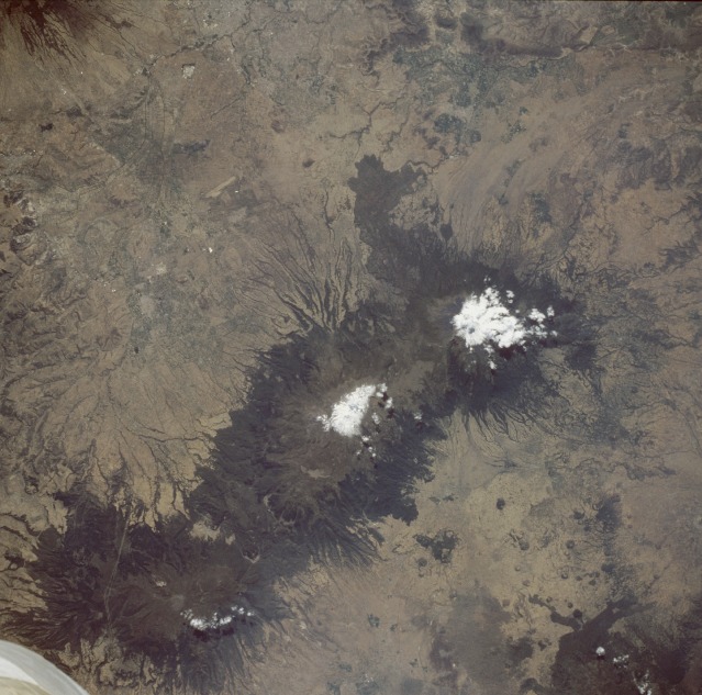 |
| STS51B-034-0080 Popocatepetl and Ixtaccihuatl Volcanoes, Mexico April 1985 Three individual volcanoes, aligned in a general north-south direction and located about 45 miles (72 kilometers) southeast of Mexico City on the Mexican Plateau, are clearly visible in this near-vertical photograph. The classic radial erosion drainage pattern associated with most stratovolcanoes is very evident around the flanks of all these volcanoes. Upon close inspection, numerous cinder cones can be seen, especially on the plains west of the volcanoes. Two of the volcanoes, Ixtaccihuatl [17 343 feet (5285 meters)] and Popocatepetl [17 887 feet (5452 meters)] have snow-covered summits. Clouds partially obscure Popocatepetl's large oval crater that measures approximately 2000 feet (600 meters) in diameter and more than 500 feet (150 meters) in depth. Southernmost Popocatepetl is the most famous volcano in Mexico. Its name was derived from an ancient Aztec word meaning "the smoking mountain." Eruptions of the volcano in the mid 1990s put Mexico City and the surrounding communities on alert. The last known eruptions of Popocatepetl before the mid 1990s occurred in the 17th century. The linear feature east of volcano appears to be an airport runway. |
| Images: | All Available Images Low-Resolution 126k |
|
| Mission: | STS51B |
|
| Roll - Frame: | 34 - 80 |
|
| Geographical Name: | MEXICO |
|
| Features: | POPOCATEPETL, PUEBLA |
|
| Center Lat x Lon: | 19.0N x 98.5W |
|
| Film Exposure: | N | N=Normal exposure, U=Under exposed, O=Over exposed, F=out of Focus |
| Percentage of Cloud Cover-CLDP: | 2 |
|
| Camera:: | HB |
|
| Camera Tilt: | NV | LO=Low Oblique, HO=High Oblique, NV=Near Vertical |
| Camera Focal Length: | 250 |
|
| Nadir to Photo Center Direction: | The direction from the nadir to the center point, N=North, S=South, E=East, W=West |
|
| Stereo?: | Y | Y=Yes there is an adjacent picture of the same area, N=No there isn't |
| Orbit Number: | 17 |
|
| Date: | 1985____ | YYYYMMDD |
| Time: | GMT HHMMSS |
|
| Nadir Lat: | N |
Latitude of suborbital point of spacecraft |
| Nadir Lon: | E |
Longitude of suborbital point of spacecraft |
| Sun Azimuth: | Clockwise angle in degrees from north to the sun measured at the nadir point |
|
| Space Craft Altitude: | nautical miles |
|
| Sun Elevation: | Angle in degrees between the horizon and the sun, measured at the nadir point |
|
| Land Views: | MOUNTAIN, VOLCANO, PLAIN, FOREST |
|
| Water Views: | RIVER |
|
| Atmosphere Views: | |
|
| Man Made Views: | AIRPORT, AGRICULTURE |
|
| City Views: | |
|
Photo is not associated with any sequences | ||
| NASA Home Page |
JSC Home Page |
JSC Digital Image Collection |
Earth Science & Remote Sensing |
|
This service is provided by the International Space Station program and the JSC Earth Science & Remote Sensing Unit, ARES Division, Exploration Integration Science Directorate.

|