
Geographic Region: USA-NEW YORK
Feature: ADIRONDACK MOUNTAINS
|
Geographic Region: USA-NEW YORK Feature: ADIRONDACK MOUNTAINS |
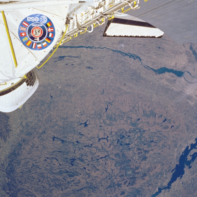 |
| STS51B-33-0032 St. Lawrence River, Adirondack Mountains, New York May 1985 With the Space Shuttle covering the upper portions of the image, the rugged Adirondack Mountains are visible in this northwest-looking view. The Adirondacks are considered a part of the Laurentian Plateau of eastern Canada. The mountain range is bordered to the east by Lake Champlain and the Hudson River Valley (lower left); to the south by the Mohawk River Valley; to the west by the Black River Valley (lower left); and to the north by the St. Lawrence River lowland. Composed chiefly of metamorphic rocks, the Adirondacks were formed as igneous rocks (mainly granite), and intruded upward. Subsequent faulting of the earth's crust and surface erosion, particularly by glaciers, gives the mountains their rugged topography. The glaciers, the last of which occurred over 10000 years ago, have carved scenic gorges, waterfalls, and numerous lakes throughout the range. The Adirondacks are the source of the Hudson and Ausable Rivers. The mountain range continues to rise about three millimeters a year. The region is a year-around resort and recreational area. |
| Images: | All Available Images Low-Resolution 352k |
|
| Mission: | STS51B |
|
| Roll - Frame: | 33 - 32 |
|
| Geographical Name: | USA-NEW YORK |
|
| Features: | ADIRONDACK MOUNTAINS |
|
| Center Lat x Lon: | 44.5N x 75W |
|
| Film Exposure: | N | N=Normal exposure, U=Under exposed, O=Over exposed, F=out of Focus |
| Percentage of Cloud Cover-CLDP: | 0 |
|
| Camera:: | HB |
|
| Camera Tilt: | NV | LO=Low Oblique, HO=High Oblique, NV=Near Vertical |
| Camera Focal Length: | 100 |
|
| Nadir to Photo Center Direction: | The direction from the nadir to the center point, N=North, S=South, E=East, W=West |
|
| Stereo?: | Y | Y=Yes there is an adjacent picture of the same area, N=No there isn't |
| Orbit Number: | 17 |
|
| Date: | 1985____ | YYYYMMDD |
| Time: | GMT HHMMSS |
|
| Nadir Lat: | N |
Latitude of suborbital point of spacecraft |
| Nadir Lon: | E |
Longitude of suborbital point of spacecraft |
| Sun Azimuth: | Clockwise angle in degrees from north to the sun measured at the nadir point |
|
| Space Craft Altitude: | nautical miles |
|
| Sun Elevation: | Angle in degrees between the horizon and the sun, measured at the nadir point |
|
| Land Views: | MOUNTAIN, FAULT |
|
| Water Views: | RIVER, LAKE |
|
| Atmosphere Views: | |
|
| Man Made Views: | |
|
| City Views: | |
|
Photo is not associated with any sequences | ||
| NASA Home Page |
JSC Home Page |
JSC Digital Image Collection |
Earth Science & Remote Sensing |
|
This service is provided by the International Space Station program and the JSC Earth Science & Remote Sensing Unit, ARES Division, Exploration Integration Science Directorate.

|