
Geographic Region: USA-NEW YORK
Feature: LAKE ONTARIO, FINGER LAKES
|
Geographic Region: USA-NEW YORK Feature: LAKE ONTARIO, FINGER LAKES |
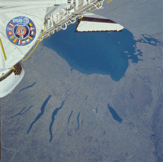 |
| STS51B-033-0029 Finger Lakes Area, New York, U.S.A. April 1985 The elongated lakes of north-central New York State, known as the Finger Lakes, are graphic reminders of the continental glaciers or ice sheet that covered the northeastern part of the North American continent during the last great ice age, which ended 10 000 to 15 000 years ago. As the massive ice sheet moved generally south, it had a bulldozing effect on most of the landscape. The scouring, abrasive action caused an erosion process, creating the valleys that have since filled with water. As the continental glaciers retreated to the north into Quebec, Canada, some rock and soil debris (known as drift or till) stored in the glacier was deposited over the landscape. Numerous lakes of various sizes can be seen in this photograph, including the eastern part of Lake Ontario. The two longest Finger Lakes are Seneca Lake (west) and Cayuga Lake (east). Oneida Lake is the larger, roughly rectangular-shaped lake near the eastern edge of the photograph. Even at the distance from which this photograph was taken, some of the agricultural field patterns can be seen. (Refer to photograph STS-61A-034-0020 for a more detailed view of the agricultural field patterns around Seneca Lake and Cayuga Lake.) |
| Images: | All Available Images Low-Resolution 113k |
|
| Mission: | STS51B |
|
| Roll - Frame: | 33 - 29 |
|
| Geographical Name: | USA-NEW YORK |
|
| Features: | LAKE ONTARIO, FINGER LAKES |
|
| Center Lat x Lon: | 43.0N x 76.5W |
|
| Film Exposure: | N | N=Normal exposure, U=Under exposed, O=Over exposed, F=out of Focus |
| Percentage of Cloud Cover-CLDP: | 0 |
|
| Camera:: | HB |
|
| Camera Tilt: | LO | LO=Low Oblique, HO=High Oblique, NV=Near Vertical |
| Camera Focal Length: | 100 |
|
| Nadir to Photo Center Direction: | The direction from the nadir to the center point, N=North, S=South, E=East, W=West |
|
| Stereo?: | Y | Y=Yes there is an adjacent picture of the same area, N=No there isn't |
| Orbit Number: | 17 |
|
| Date: | 1985____ | YYYYMMDD |
| Time: | GMT HHMMSS |
|
| Nadir Lat: | N |
Latitude of suborbital point of spacecraft |
| Nadir Lon: | E |
Longitude of suborbital point of spacecraft |
| Sun Azimuth: | Clockwise angle in degrees from north to the sun measured at the nadir point |
|
| Space Craft Altitude: | nautical miles |
|
| Sun Elevation: | Angle in degrees between the horizon and the sun, measured at the nadir point |
|
| Land Views: | PLAIN, HILL, VALLEY |
|
| Water Views: | LAKE, RIVER |
|
| Atmosphere Views: | |
|
| Man Made Views: | AGRICULTURE |
|
| City Views: | |
|
Photo is not associated with any sequences | ||
| NASA Home Page |
JSC Home Page |
JSC Digital Image Collection |
Earth Science & Remote Sensing |
|
This service is provided by the International Space Station program and the JSC Earth Science & Remote Sensing Unit, ARES Division, Exploration Integration Science Directorate.

|