
Geographic Region: FRANCE
Feature: PYRENEES
|
Geographic Region: FRANCE Feature: PYRENEES |
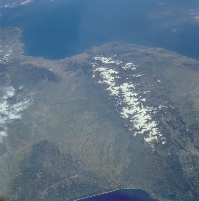 |
| STS51B-31-81 Pyrenees Mountains, France and Spain April 1985 The snow-covered Pyrenees Mountains, which form a formidable physical barrier between France to the north and Spain to the south, are the main focus of this low-oblique, southeast-looking photograph. Scarcely interrupted by accessible passes and pierced in only two places by railroad tunnels, the Pyrenees are an ideal natural boundary between the Iberian Peninsula and the rest of Europe. The northern flank of the Pyrenees is characterized by a series of large alluvial deposits that fan out across southwestern France. The darker, roughly triangular area in southwest France is part of the forested Aquitaine Basin. This region is near the major port city of Bordeaux (not visible in this photograph), which is known for its world-famous wine production. The southern flank of the Pyrenees (Spain) is characterized by aridity and very rugged, mountainous conditions. Human settlement is sparse throughout the Pyrenees; however, because the region is rich in mineral waters, there are dozens of mineral water resorts, and winter sports attract visitors from southwestern France. The very small mountainous country of Andorra (not distinguishable in this photograph) has survived in an inaccessible upper valley of the Pyrenees. |
| Images: | All Available Images Low-Resolution 98k |
|
| Mission: | STS51B |
|
| Roll - Frame: | 31 - 81 |
|
| Geographical Name: | FRANCE |
|
| Features: | PYRENEES |
|
| Center Lat x Lon: | 43.0N x 1.5E |
|
| Film Exposure: | N | N=Normal exposure, U=Under exposed, O=Over exposed, F=out of Focus |
| Percentage of Cloud Cover-CLDP: | 10 |
|
| Camera:: | HB |
|
| Camera Tilt: | LO | LO=Low Oblique, HO=High Oblique, NV=Near Vertical |
| Camera Focal Length: | 100 |
|
| Nadir to Photo Center Direction: | E | The direction from the nadir to the center point, N=North, S=South, E=East, W=West |
| Stereo?: | N | Y=Yes there is an adjacent picture of the same area, N=No there isn't |
| Orbit Number: | 14 |
|
| Date: | 19850430 | YYYYMMDD |
| Time: | 120228 | GMT HHMMSS |
| Nadir Lat: | 44.6N |
Latitude of suborbital point of spacecraft |
| Nadir Lon: | 4.7W |
Longitude of suborbital point of spacecraft |
| Sun Azimuth: | 173 | Clockwise angle in degrees from north to the sun measured at the nadir point |
| Space Craft Altitude: | 194 | nautical miles |
| Sun Elevation: | 60 | Angle in degrees between the horizon and the sun, measured at the nadir point |
| Land Views: | MOUNTAIN, PLAIN, VALLEY, FOREST |
|
| Water Views: | SEA, RIVER |
|
| Atmosphere Views: | |
|
| Man Made Views: | AGRICULTURE |
|
| City Views: | |
|
Photo is not associated with any sequences | ||
| NASA Home Page |
JSC Home Page |
JSC Digital Image Collection |
Earth Science & Remote Sensing |
|
This service is provided by the International Space Station program and the JSC Earth Science & Remote Sensing Unit, ARES Division, Exploration Integration Science Directorate.

|