
Geographic Region: USA-UTAH
Feature: GR. SALT LAKE, EDDY
|
Geographic Region: USA-UTAH Feature: GR. SALT LAKE, EDDY |
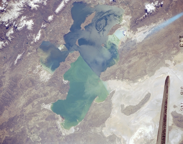 |
| STS51B-146-0119 Great Salt Lake, Utah, U.S.A. May 1985 The Great Salt Lake, the largest salt lake in North America, is featured in this spectacular, south-southeast-looking, low-oblique photograph. The lake is a remnant of a much larger prehistoric lake that covered portions of present-day Idaho, Nevada, and Utah 12 000 years ago. Dependent on precipitation, the Great Salt Lake fluctuates in size seasonally and yearly. This photograph shows a water level higher than usual because of above-normal precipitation in preceding years. A railway causeway bisects the lake--the northern, greenish half with a higher concentration of salt is much shallower than the bluish southern half. Visible counterclockwise from the upper left corner are the snowcapped Wasatch Range; center-pivot irrigation fields; and the Great Salt Lake Desert, once the floor of ancient Lake Bonneville. |
| Images: | All Available Images Low-Resolution 259k |
|
| Mission: | STS51B |
|
| Roll - Frame: | 146 - 119 |
|
| Geographical Name: | USA-UTAH |
|
| Features: | GR. SALT LAKE, EDDY |
|
| Center Lat x Lon: | 41.2N x 112.8W |
|
| Film Exposure: | N | N=Normal exposure, U=Under exposed, O=Over exposed, F=out of Focus |
| Percentage of Cloud Cover-CLDP: | 0 |
|
| Camera:: | LH |
|
| Camera Tilt: | LO | LO=Low Oblique, HO=High Oblique, NV=Near Vertical |
| Camera Focal Length: | 250 |
|
| Nadir to Photo Center Direction: | The direction from the nadir to the center point, N=North, S=South, E=East, W=West |
|
| Stereo?: | Y | Y=Yes there is an adjacent picture of the same area, N=No there isn't |
| Orbit Number: | 34 |
|
| Date: | 1985____ | YYYYMMDD |
| Time: | GMT HHMMSS |
|
| Nadir Lat: | N |
Latitude of suborbital point of spacecraft |
| Nadir Lon: | E |
Longitude of suborbital point of spacecraft |
| Sun Azimuth: | Clockwise angle in degrees from north to the sun measured at the nadir point |
|
| Space Craft Altitude: | nautical miles |
|
| Sun Elevation: | Angle in degrees between the horizon and the sun, measured at the nadir point |
|
| Land Views: | DESERT, BASIN |
|
| Water Views: | LAKE |
|
| Atmosphere Views: | |
|
| Man Made Views: | |
|
| City Views: | |
|
Photo is not associated with any sequences | ||
| NASA Home Page |
JSC Home Page |
JSC Digital Image Collection |
Earth Science & Remote Sensing |
|
This service is provided by the International Space Station program and the JSC Earth Science & Remote Sensing Unit, ARES Division, Exploration Integration Science Directorate.

|