
Geographic Region: BRAZIL
Feature: REPRESA TRES MARIAS
|
Geographic Region: BRAZIL Feature: REPRESA TRES MARIAS |
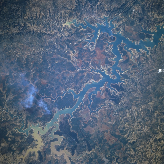 |
| STS51A-45-0044 Tres Marias Reservoir, Minas Gerais, Brazil November 1984 Located in Minas Gerais state in southwest Brazil, the serpentine-shaped Tres Marias Reservoir (blue, elongated feature) extends diagonally across the image for roughly 60 miles (97km). The reservoir is aligned in a general south-north direction with the dam located just outside of the northeast corner (upper right) of the image. Numerous tributary streams are visible as they drain into every part of the large reservoir. Sediment (lighter-colored tan in stream channels) is carried into the southern end of the reservoir by the larger recharge streams including the Sao Francisco River (channel closest lower left corner of the image). The darker, uniform-looking landscape along both sides of the reservoir is hilly forest. Small plumes of smoke can be seen along the southwest side of the reservoir. |
| Images: | All Available Images Low-Resolution 391k |
|
| Mission: | STS51A |
|
| Roll - Frame: | 45 - 44 |
|
| Geographical Name: | BRAZIL |
|
| Features: | REPRESA TRES MARIAS |
|
| Center Lat x Lon: | 18.5S x 45.5W |
|
| Film Exposure: | N | N=Normal exposure, U=Under exposed, O=Over exposed, F=out of Focus |
| Percentage of Cloud Cover-CLDP: | 0 |
|
| Camera:: | HB |
|
| Camera Tilt: | NV | LO=Low Oblique, HO=High Oblique, NV=Near Vertical |
| Camera Focal Length: | 250 |
|
| Nadir to Photo Center Direction: | The direction from the nadir to the center point, N=North, S=South, E=East, W=West |
|
| Stereo?: | Y | Y=Yes there is an adjacent picture of the same area, N=No there isn't |
| Orbit Number: | 5 |
|
| Date: | 198411__ | YYYYMMDD |
| Time: | GMT HHMMSS |
|
| Nadir Lat: | N |
Latitude of suborbital point of spacecraft |
| Nadir Lon: | E |
Longitude of suborbital point of spacecraft |
| Sun Azimuth: | Clockwise angle in degrees from north to the sun measured at the nadir point |
|
| Space Craft Altitude: | nautical miles |
|
| Sun Elevation: | Angle in degrees between the horizon and the sun, measured at the nadir point |
|
| Land Views: | HILL, FOREST |
|
| Water Views: | RESERVOIR, RIVER |
|
| Atmosphere Views: | SMOKE |
|
| Man Made Views: | |
|
| City Views: | |
|
Photo is not associated with any sequences | ||
| NASA Home Page |
JSC Home Page |
JSC Digital Image Collection |
Earth Science & Remote Sensing |
|
This service is provided by the International Space Station program and the JSC Earth Science & Remote Sensing Unit, ARES Division, Exploration Integration Science Directorate.

|